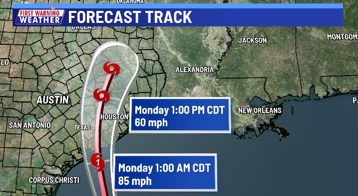
AUSTIN (KXAN) — Tropical Storm Beryl is expected to become a hurricane tonight just before landfall. Landfall is expected near Matagorda Bay before sunrise Monday morning. From there, the storm should gradually weaken as it moves northward.
Despite initial projections of some significant rain and wind locally, it now appears Beryl will move much closer to Houston than Austin during the day Monday. This means far less rain and wind for most of the KXAN viewing area, with a couple of exceptions.
Due to the continued track shifts eastward, the ‘cone of uncertainty’ no longer covers any of the KXAN viewing area except for extreme eastern Fayette County.
Fayette County is now included in a Tropical Storm Warning, meaning there is a potential for sustained winds over 39 mph and gusts over 50 mph.
Tropical storm force winds and excessive rainfall are now only expected in Fayette, and possibly Lee counties. Milam County could also experience flash flood producing rainfall.

Since the track of Beryl will be so far east of Austin, the main impacts of the storm will be felt over Milam, Lee and Fayette Counties. This is where we could see some heavy rainfall on the order of 2 to 3 inches, with possible higher totals. A Flood Watch is in effect for those counties beginning tonight into Tuesday morning.

For the rest of Central Texas, rain totals will sharply drop off from east to west. Areas along the I-35 corridor are expected to receive around and inch or less, with the Hill Country seeing the least at around a quarter inch.

Winds could be a bit gusty at times, especially east of Austin where winds could reach over 40 miles per hour.
Beryl will quickly weaken and accelerate northeastward Monday night into Tuesday. Overall, this will be a fairly quick event on Monday. For Tuesday and the rest of the week ahead, we will see partly sunny skies with daily afternoon rain chances around 20 to 30 percent. Highs will be climbing back into the 90s on Tuesday, and by the weekend, upper 90s are expected with no rain.
What is the ‘Cone of Uncertainty’?
The updated Cone of Uncertainty now only includes extreme eastern Fayette County.

Coastal watches and warnings
A Storm Surge Warning is in effect for… * North Entrance of the Padre Island National Seashore to Sabine Pass, including Corpus Christi Bay, Matagorda Bay, and Galveston Bay
A Hurricane Warning is in effect for… * The Texas coast from Baffin Bay northward to San Luis Pass
A Hurricane Watch is in effect for… * The Texas coast north of San Luis Pass to Galveston Island
A Tropical Storm Warning is in effect for… * The Texas coast south of Baffin Bay to the mouth of the Rio Grande * The Texas coast north of San Luis Pass to Sabine Pass * The northeastern coast of mainland Mexico from Barra el Mezquital to the mouth of the Rio Grande River
A Storm Surge Watch is in effect for… * North of Baffin Bay, Texas to North Entrance of the Padre Island National Seashore
A Hurricane Warning means that hurricane conditions are expected somewhere within the warning area. Preparations to protect life and property should be rushed to completion. A Hurricane Watch means that hurricane conditions are possible within the watch area. A Tropical Storm Warning means that tropical storm conditions are expected within the warning area. A Storm Surge Warning means there is a danger of life-threatening inundation, from rising water moving inland from the coastline, during the next 36 hours in the indicated locations.
For a depiction of areas at risk, please see the National Weather Service Storm Surge Watch/Warning Graphic, available at hurricanes.gov. This is a life-threatening situation. Persons located within these areas should take all necessary actions to protect life and property from rising water and the potential for other dangerous conditions. Promptly follow evacuation and other instructions from local officials.
A Storm Surge Watch means there is a possibility of life- threatening inundation, from rising water moving inland from the coastline. Interests elsewhere along the northwestern Gulf of Mexico coast should closely monitor the progress of Beryl.
Stay with the First Warning Weather Team to stay up to date with the latest forecast.
How often does Austin hit 100°? Here’s a breakdown by date, month, year and decade
BLOG: July forecast released. What to expect in Central Texas
Tropical tracker: Timeline of storms in the 2024 Atlantic hurricane season
Summer outlook: Will Central Texas lakes fill with rain?
Summer outlook: How a flip to La Niña could stir the Gulf and affect Central Texas
Summer outlook: How hot will it be and will the grid hold
FIRST WARNING WEATHER: Stay up to date with your Central Texas forecast, sign up for our weather newsletter at kxan.com/newsletters
Stay up-to-date with the First Warning Weather team
Follow the KXAN First Warning Weather team on Facebook, Twitter and Instagram.
You can also follow our meteorologists’ individual accounts for livestreams and a little bit of what goes on behind the scenes:
Copyright 2024 Nexstar Media, Inc. All rights reserved. This material may not be published, broadcast, rewritten, or redistributed.
For the latest news, weather, sports, and streaming video, head to KXAN Austin.
EMEA Tribune is not involved in this news article, it is taken from our partners and or from the News Agencies. Copyright and Credit go to the News Agencies, email news@emeatribune.com Follow our WhatsApp verified Channel


