A typhoon has killed more than a dozen people as it approaches Taiwan and China. The typhoon, named Gaemi by Japan’s Meteorological Agency and Carina by the Philippines weather service, is expected to be the strongest typhoon to hit Taiwan in eight years, according to Reuters.
As of late Wednesday, Typhoon Gaemi/Carina was the equivalent of a Category 3 hurricane (maximum sustained winds of 111-129 mph or 178-208 km/h) on the Saffir-Simpson Hurricane Wind Scale. Gaemi will track across northern Taiwan on Wednesday night, local time, before emerging over the Taiwan Strait on Thursday morning.
Rain in Taiwan has been extreme so far, with feet of rain falling in the mountains. As of early Thursday morning, 42.36 inches (1,076 mm) of rain had fallen since Monday at Taipingshan, with 39.62 inches (1006.5 mm) at Cuifenghu.
 |
|
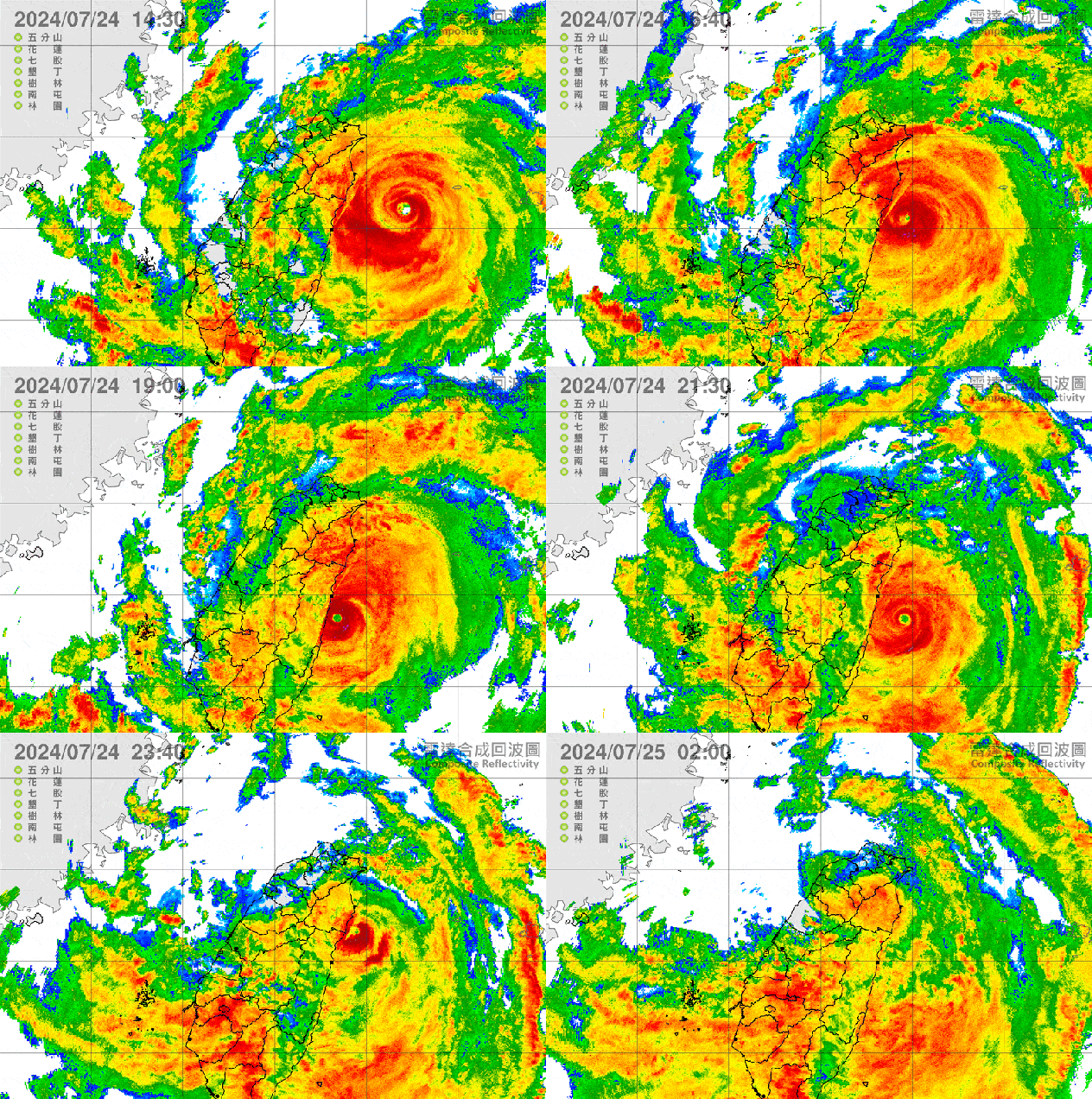
Taiwan weather radar loop showing Typhoon Gaemi 7 a.m. Wednesday to 2 a.m. Thursday local time. (Central Weather Administration) |
Earlier on Wednesday, the typhoon performed a loop in its track, approaching the coast of Taiwan before grazing the coast and moving east, then turning around and making landfall just before midnight. This phenomenon is caused by interaction with the mountains in Taiwan and is not unusual for storms in the area, AccuWeather Lead International Expert Jason Nichols says.
“The loop in Gaemi’s track is due to being deflected off the mountainous coast of Taiwan due to orographic blocking, causing an asymmetric flow over the center of the typhoon,” Nichols explained.
Although not directly impacting the Philippines, Typhoon Gaemi/Carina has caused severe flooding in the archipelago, where more than a dozen people have already been killed, according to The Associated Press. The Philippine Coast Guard reported being overwhelmed with flood rescue requests for residents in the capital city of Manila.
 |
Interaction with the mountains in Taiwan will also cause the storm to lose wind intensity, but the storm could regain some strength over the strait before making another landfall in eastern China’s Fujian province Thursday evening or night, local time. Due to the impacts, Gaemi/Carina is a 4 on the AccuWeather RealImpact™ Scale for tropical cyclones in Taiwan and a 2 in eastern China.
The typhoon will bring a swath of heavy rain to the northern Philippines, southern Ryukyu Islands and Taiwan and China’s Zhejiang, Fujian and eastern Guangdong provinces Wednesday into Saturday, local time. Rain will spread northward and reach Henan, Shandong, Shanxi and Hebei provinces in China from Saturday night into Monday, local time. Rainfall totals will be up to 24 inches (600 mm) in Fujian and into southern Zhejiang provinces of China with an AccuWeather Local StormMax™ of 36 inches (900 mm), which will lead to flooding, mudslides and extended transportation and logistical delays.
 |
Wind gusts to 140 mph (225 km/h), with an AccuWeather Local StormMax™ of 170 mph (270 km/h) are expected across northern Taiwan and parts of the east coast of China near the center of the storm. This is expected to lead to power outages and structural damage. In eastern China, impacts from the wind can reach northward to the Yangtze River Valley from Friday into the weekend.
Other than Gaemi/Carina, additional tropical development is not expected across the basin through the weekend. Conditions can remain marginally conducive for development over the Philippine Sea next week.
EMEA Tribune is not involved in this news article, it is taken from our partners and or from the News Agencies. Copyright and Credit go to the News Agencies, email news@emeatribune.com Follow our WhatsApp verified Channel


