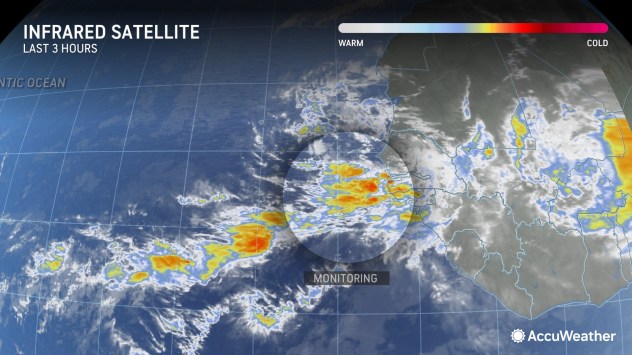
An area of low pressure recently pushed off the coast of Africa and into the eastern tropical Atlantic. AccuWeather meteorologists say if it survives the swath of dry air and dust in its path, there is the potential for development and the likelihood of a surge of tropical activity in August.
Ripples of low pressure in the atmosphere continuously move from the Indian Ocean, across Africa and into the tropical Atlantic and Pacific basins throughout late spring, summer and early autumn. The vast majority of these tropical waves, as they are called, do not develop. However, once in a while, they gather enough moisture and begin to spin and intensify.
 |
“We are approaching the point of the season [August] where we tend to see more of these systems take hold and organize into tropical depressions, storms, and even hurricanes under the right conditions,” AccuWeather Lead Hurricane Expert Alex DaSilva said.
As August moves in, dry air, dust and disruptive breezes, called wind shear, tend to diminish, while at the same time, the oceans are approaching maximum warmth.
“Dry air, dust and wind shear will be factors against short- to medium-range tropical development of a robust tropical wave that pushed westward and just off the coast of Africa on Thursday morning,” AccuWeather Chief On-Air Meteorologist Bernie Rayno said.
 |
“If that system is able to survive the hostile conditions as it continues westward, it may encounter more favorable conditions for tropical development near the Caribbean around the start of August,” Rayno added.
Since Beryl churned through the area several weeks ago, the ocean water has had plenty of time to recover its unusual warmth and throughout much of the system’s path, that warm water will be favorable for development.
Very warm water, low wind shear and moisture helped Beryl set records for Atlantic early-season development, including the earliest Category 5 hurricane. A Category 5 hurricane is the highest level on the Saffir-Simpson hurricane wind scale, with winds of 157 mph or greater. Beryl’s peak winds reached 165 mph, while over the eastern Caribbean Sea.
 |
Current steering breezes would guide the system near the northern islands of the Caribbean from the Leewards to some of the Greater Antilles in early August. A close encounter with a formidable tropical system could lead to dangers from flooding rain, storm surge and high winds.
At the very least, this system in a weaker form, as a tropical wave, would bring an uptick in drenching showers and gusty thunderstorms.
Have the app? Unlock AccuWeather Alerts™ with Premium+
Since the winter, AccuWeather’s team of forecasters, led by Lead Hurricane Expert Alex DaSilva, Chief Meteorologist Jonathan Porter and Lead Long-Range Meteorologist Paul Pastelok, have been warning of a super-charged Atlantic hurricane season for 2024.
In the spring, AccuWeather meteorologists also raised the likelihood of multiple storms with the potential to intensify rapidly, which would be an added danger as the systems approach land. Months later, Beryl made AccuWeather’s concern a reality as it blasted across the Windward Islands in the southeastern Caribbean.
 |
“We are expecting a significant uptick in Atlantic tropical activity beginning in August, regardless of whether the wave near Africa on Thursday develops later on or not,” DaSilva said.
A lesser-known phenomenon to the public, the Madden-Julian Oscillation (MJO), may help boost the anticipated Atlantic uptick in August. This large wave of rising air tends to slowly circle the globe from west to east over the course of one to two months. It may have contributed to tropical development in the western Pacific in mid-July [Typhoon Gaemi] and, more recently, the eastern Pacific [Tropical Storm Bud].
Waters over much of the prime tropical development zone just north of the Equator in the Atlantic to the Caribbean and the Gulf are much warmer than the historical average, so as wind shear, Sahara Desert dust and dry air drop off, there may be a frenzy of tropical systems at times from August to September and October.
 |
|
Peak Timing / Frequency of Hurricane Season |
Want next-level safety, ad-free? Unlock advanced, hyperlocal severe weather alerts when you subscribe to Premium+ on the AccuWeather app. AccuWeather Alerts™ are prompted by our expert meteorologists who monitor and analyze dangerous weather risks 24/7 to keep you and your family safer.
EMEA Tribune is not involved in this news article, it is taken from our partners and or from the News Agencies. Copyright and Credit go to the News Agencies, email news@emeatribune.com Follow our WhatsApp verified Channel


