Article first published: Saturday, Aug. 03, 2024, 5 a.m. ET
Article last updated: Saturday, Aug. 03, 2024, 11 a.m. ET
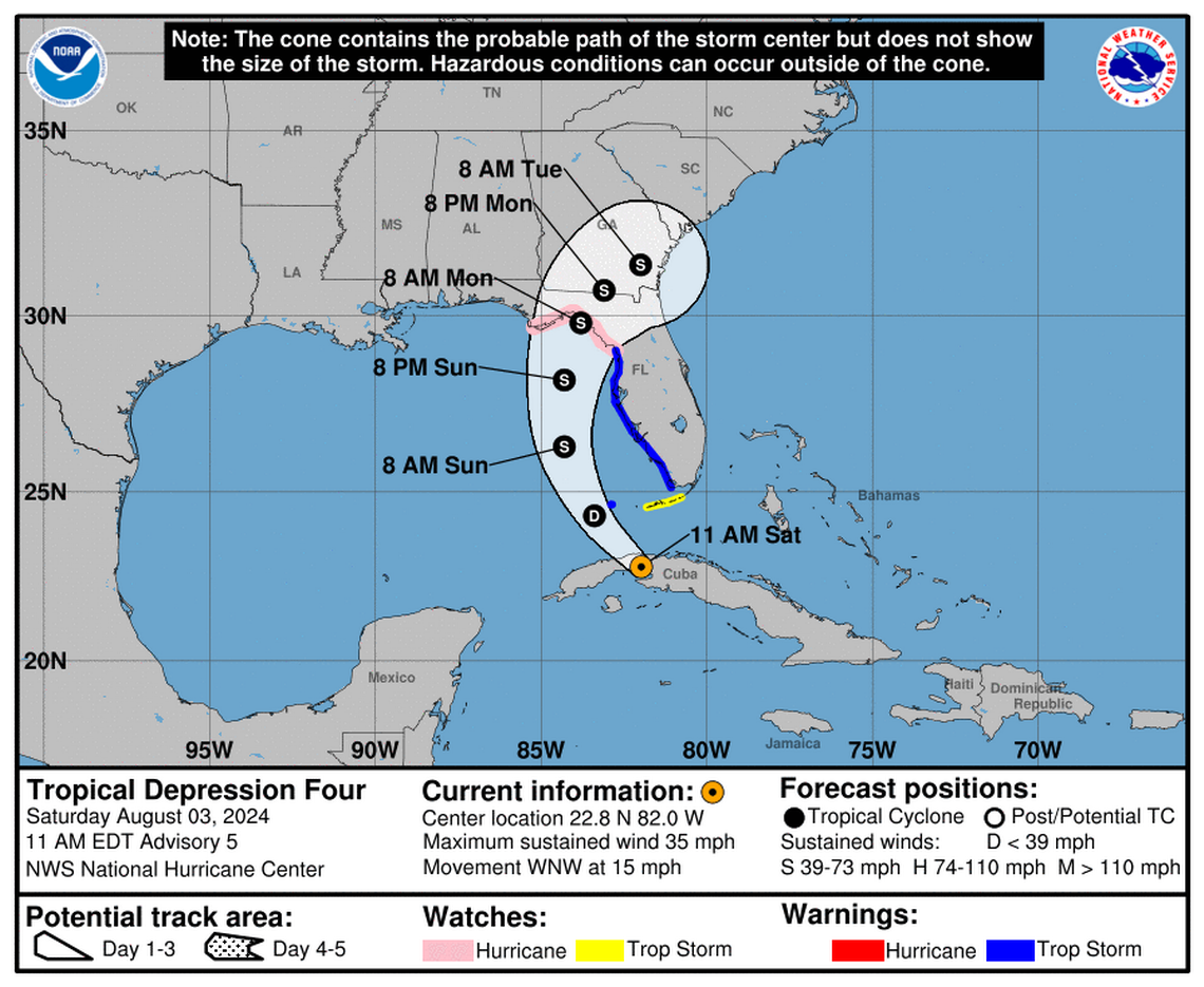
According to the National Hurricane Center’s 11 am Saturday advisory, the tropical depression is now impacting Cuba
The tropical depression is 40 miles southeast of Havana Cuba and 125 miles south of Key West Florida, with maximum sustained wind of 35 mph. It’s moving 15 mph to the west-northwest. The tropical depression is forecast to strengthen.
YESTERDAY (Friday):
Yesterday (Friday) at 11 am, the National Hurricane Center published the first advisory for a potential tropical cyclone. The tropical depression departed Cuba and moved toward the Caribbean Sea. The system became a tropical depression with sustained winds of 35 mph after intensifying from a potential tropical cyclone
Portions of Florida placed under a tropical storm warning and a tropical storm watch by forecasters.
CHANGES WITH THIS ADVISORY:
A Hurricane Watch is now in effect for the Florida coast west of the Aucilla River to Indian Pass.
A Storm Surge Warning is now in effect for the coast of Florida from Aripeka to the mouth of the Aucilla River.
A Storm Surge Watch is now in effect for the coast of Florida west of the mouth of the Aucilla River to Indian Pass.
SUMMARY OF WATCHES AND WARNINGS IN EFFECT:
A Hurricane Watch is in effect for:
– Indian Pass to Yankeetown
A Tropical Storm Warning is in effect for:
– The Dry Tortugas
– West coast of the Florida peninsula from south of Yankeetown to East Cape Sable
A Tropical Storm Watch is in effect for:
– The Florida Keys south of the Channel 5 Bridge A Storm Surge Warning is in effect for
* Aripeka northward to the Aucilla River A Storm Surge Watch is in effect for:
– Bonita Beach northward to Aripeka, including Tampa Bay and Charlotte Harbor
– West of the Aucilla River to Indian Pass
A Tropical Storm Warning means that tropical storm conditions are expected somewhere within the warning area within 36 hours.
A Hurricane Watch means that hurricane conditions are possible within the watch area. A watch is typically issued 48 hours before the anticipated first occurrence of tropical-storm-force winds, conditions that make outside preparations difficult or dangerous.
A Tropical Storm Watch means that tropical storm conditions are possible within the watch area, generally within 48 hours.
A Storm Surge Warning means there is a danger of life-threatening inundation, from rising water moving inland from the coastline, during the next 36 hours in the indicated locations. For a depiction of areas at risk, please see the National Weather Service Storm Surge Watch/Warning Graphic, available at hurricanes.gov.
This is a life-threatening situation. Persons located within these areas should take all necessary actions to protect life and property from rising water and the potential for other dangerous conditions.
Promptly follow evacuation and other instructions from local officials.
A Storm Surge Watch means there is a possibility of life- threatening inundation, from rising water moving inland from the coastline, in the indicated locations during the next 48 hours. For a depiction of areas at risk, please see the National Weather Service Storm Surge Watch/Warning Graphic, available at hurricanes.gov.
Interests elsewhere in Florida and the southeastern coast of the United States should monitor the progress of this system. Additional warnings and watches will likely be required for a portion of this area later today.
HAZARDS AFFECTING LAND:
WIND: Hurricane conditions are possible in the hurricane watch area by Sunday night, with tropical storm conditions possible earlier on Sunday. Tropical storm conditions are expected to spread northward over the warning areas beginning later today and continuing through Sunday. Tropical storm conditions are possible in the watch area in the Florida Keys later today or tonight, and in the Florida Panhandle by late Sunday. Wind gusts to tropical storm force are currently occurring over the Florida Keys.
STORM SURGE: The combination of storm surge and tide will cause normally dry areas near the coast to be flooded by rising waters moving inland from the shoreline. The water could reach the following heights above ground somewhere in the indicated areas if the peak surge occurs at the time of high tide…
Aripeka, FL to Aucilla River, FL…3-5 ft Aucilla River, FL to Indian Pass, FL…2-4 ft Bonita Beach, FL to Aripeka, FL…2-4 ft Tampa Bay…2-4 ft Charlotte Harbor…2-4 ft For a complete depiction of areas at risk of storm surge inundation,
Please see the National Weather Service Peak Storm Surge Graphic,
Available at hurricanes.gov/graphics_at4.shtml? PeakSurge.
RAINFALL: Tropical Depression Four is expected to produce rainfall totals of 5 to 10 inches, with maximum rainfall totals up to 15 inches, across portions of Florida and along the Southeast U.S. coast this weekend through Thursday morning. This rainfall will likely result in areas of locally considerable flash and urban flooding, with river flooding expected.
For Cuba, rainfall amounts of 1 to 2 inches, with localized higher amounts, will be possible through today. This may result in isolated to scattered areas of flooding.
For a complete depiction of forecast rainfall and flash flooding associated with Tropical Depression Four, please see the National Weather Service Storm Total Rainfall Graphic, available at hurricanes.gov/graphics_at4.shtml? Rainqpf
TORNADOES: A tornado or two is possible across the Florida Keys and the western Florida Peninsula tonight through Sunday morning.
SURF: Swells generated by the depression are expected to affect much of the Gulf coast of Florida tonight through Monday and along the Southeast U.S. coast early next week. These swells are likely to cause life-threatening surf and rip current conditions.
Source: National Hurricane Center
This article was generated by the South Carolina Bot, artificial intelligence software that analyzes information from the National Hurricane Center and applies it to templates created by journalists in the newsroom. We are experimenting with this and other new ways of providing more useful content to our readers and subscribers. You can report errors or bugs to mcclatchybot@mcclatchy.com.
EMEA Tribune is not involved in this news article, it is taken from our partners and or from the News Agencies. Copyright and Credit go to the News Agencies, email news@emeatribune.com Follow our WhatsApp verified Channel


