Quick update on the potential for tropical development in the Gulf of Mexico, which like the perpetual notifications from my watch for the last two weeks telling me I’m stressed out, is a continuing source of anxiety.
The 30,000-foot view is that a broad area of low pressure, which may or may not become a named tropical system, will likely develop in the Gulf over the weekend.
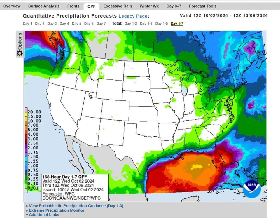
Regardless of naming rights, this low will have heavy rain impacts on the Florida peninsula and potentially elsewhere starting around Sunday and extending into next week.
The National Hurricane Center continues to give a broad area of convection and low pressure extending from the southern Gulf of Mexico into a northwestern Caribbean Sea a 40% chance of development between Friday and next Wednesday.
In the past day, there has been an increase in the amount, though not the organization, of the thunderstorm activity associated with the next round of Central American Gyre (CAG) activity.
As of Wednesday morning, there are two main areas of convection, one focused in the Bay of Campeche and the other to the south of Cuba. Water vapor imagery shows plenty of moisture across the southern Gulf and northern Caribbean, as well as increasingly favorable upper-level winds, with a much drier airmass in the northern Gulf of Mexico.

➤ Weather alerts via text: Sign up to get updates about current storms and weather events by location
With two pockets of rotation in the area, tropical development is not imminent, and it’ll take several days, at least, to consolidate the pieces into a single disturbance.
Both areas are expected to lift north into the general vicinity of south-central Gulf by the weekend, by which time they may combine into a single, broad circulation.
Is there a hurricane heading toward Florida? Not likely

The resulting area of low pressure is expected to be large, but due to increasing shear, likely will lack any kind of intense core.
Rather, a large area of rainfall is likely to spread out to the east and northeast of the low’s broad center. This rainfall will probably reach the immediate northern Gulf Coast and the Florida peninsula by late in the weekend.
With a fair amount of wind shear over the Gulf, nearby dry air to its west, and several fronts likely to be in its vicinity, it is unclear whether the resulting disturbance will actually meet the definition of tropical cyclone, or be more of a hybrid or frontal low.
That makes a difference for whether the system ever receives a name, but it doesn’t make much of a difference in the system’s eventual impacts.
What impacts can Florida expect from system moving into Gulf of Mexico?
Exactly how fast the low will move east-northeast across the eastern Gulf ahead of an approaching dip in the jet stream early next week is to be determined, but South and Central Florida are likely to tally 3 inches or more of rainfall between Sunday and Tuesday, with the potential for widespread higher totals if the storm lingers through the mid-week or beyond.
Again, while something is likely to form over the Gulf by the weekend, what develops is not likely to be a tight, well-organized hurricane, and may well not even technically be a tropical storm or depression either.
However, the label, or lack thereof, doesn’t mean that there won’t be impacts: tropical or not, the eventual rainfall accumulations are likely to be heavy in Central and South Florida. That certainly isn’t helpful for recovery efforts along the Florida Gulf Coast, nor are the potential for some gusty winds or rough seas early next week, either.
Farther north, the fact that the jet stream is likely to be oriented from west-to-east across the Southeastern U.S. means tropical moisture from this system is likely not going to be pulled into north Georgia or the Carolinas, where thankfully little rain is expected over the next 10 days.
North Florida may or may not see significant rainfall from this, depending on the structure of the low and where it forms, but rains are not likely to last as long over the Panhandle as peninsular Florida.
I know it’s stress-inducing to have a tropical pain in the liver just short of jaundice hanging out over the Gulf, but we should have a better answer for how this rainmaker may play out in a few days.
In the meantime, Florida should prep for a potentially extended heavy rainfall event next week. I’ll be back in a couple of days to talk more forecast details into the weekend. Keep watching the skies.

Dr. Ryan Truchelut is chief meteorologist at WeatherTiger, a Tallahassee company providing forensic meteorology expert witness services, and agricultural and hurricane forecasting subscription services. Visit weathertiger.com for more information. Email Truchelut at ryan@weathertiger.com.
This article originally appeared on Tallahassee Democrat: Caribbean system could mean heavy rain for Florida peninsula
EMEA Tribune is not involved in this news article, it is taken from our partners and or from the News Agencies. Copyright and Credit go to the News Agencies, email news@emeatribune.com Follow our WhatsApp verified Channel


