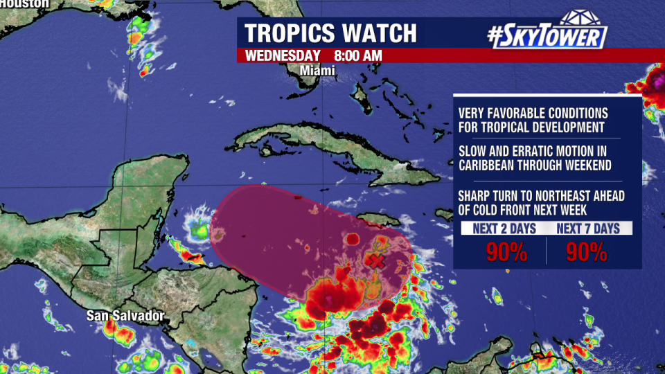
TAMPA, Fla. – The National Hurricane Center is closely watching Invest 99L, saying it will soon get the name Sara, then possibly approach Florida as a hurricane next week.
As of Wednesday morning, the NHC is giving the system a 90 percent chance to develop in the next two days.
Invest 99L is currently moving westward through the Caribbean Sea, where the water is warm and deep, meaning conditions are favorable for development.
Invest 99L is expected to soon get the name Sara, according to the National Hurricane Center.
Sara’s potential track toward Florida
FOX 13 Meteorologist Dave Osterberg says the storm is expected to meander over the Caribbean Sea for the next few days.
Advertisement
Advertisement
A strong cold front will move into the Gulf of Mexico early next week, according to Osterberg, which will push the system east.
While it’s too soon to tell where the system will go. It will likely take a sharp turn to the northeast ahead of a cold front next week.
The biggest question is how soon it will take that turn to the east. A large stretch of Florida’s Gulf coast, including the Tampa Bay area, is in play.
“It’s got nowhere to go but one of these three particular spots,” Osterberg said, pointing to southern, central and northern portions of Florida’s Gulf coast.
Any potential Florida impacts would likely occur next Wednesday, according to Osterberg.
How strong will Sara become?
Osterberg says Sara’s intensity will depend not only on water temperatures and wind shear, but also whether it moves over land before entering the Gulf.
Models show Invest 99L staying over the Caribbean Sea for the next few days before moving toward the Gulf of Mexico.
“If it interacts with the Yucatán, that would be the best case scenario,” Osterberg said. “Because it would knock it down and probably not allow it to come back up again before it makes its way into Florida.”
Advertisement
Advertisement
If the storm stays over open water, however, Sara could become a major hurricane, according to Osterberg.
STAY CONNECTED WITH FOX 13 TAMPA BAY:
EMEA Tribune is not involved in this news article, it is taken from our partners and or from the News Agencies. Copyright and Credit go to the News Agencies, email news@emeatribune.com Follow our WhatsApp verified Channel


