Do we really have to go through all of this again?
This question is on the minds of millions of Floridians as hurricane season again displays the tenacity of the cockroach and prepares to disgorge another Gulf Coast threat. While an eventual Florida impact is a possible scenario, any potential landfall remains around 7 days out, and there is still much uncertainty as to what actually moves into the Gulf next week.
If you feel that you should not have to be dealing with this, I strongly share your sentiment.
Advertisement
Advertisement
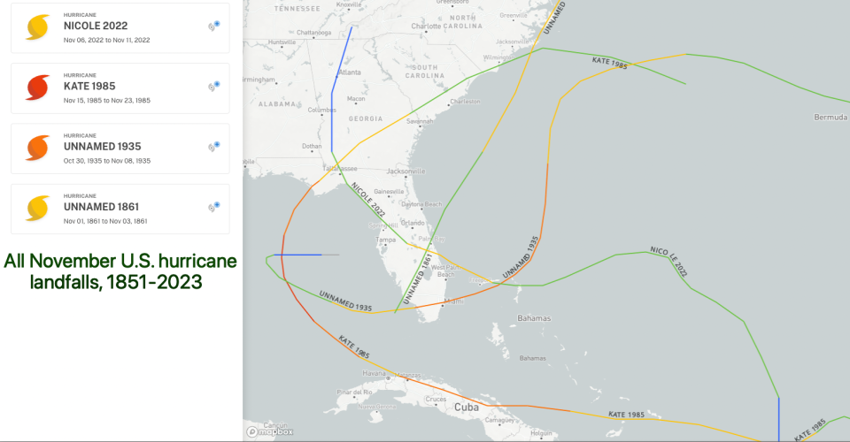
Of the 640 or so tropical storm or hurricane landfalls on record in the continental U.S. since the 1850s, only four occurred after November 15th, and just one, 1985’s Kate, was a hurricane. All storms in this tiny sample struck the Florida Gulf Coast.
It’s November, but September and October-like temps provide hurricane fuel
However, November hurricane history really isn’t the right frame of reference, as weather patterns over the past three weeks have more in common with typical conditions in late September or early October.
Temperatures to start off the month are averaging 5 degrees above normal in Miami, 10 degrees above normal in Tampa, and a whopping 15 degrees above normal in Tallahassee and elsewhere across the Deep South, coupled with minimal rainfall.
There are two key implications to the lack of decent fronts during this AWOL fall. First, the seasonal cooling of the Gulf and Caribbean has been arrested.

There are only four November hurricane landfalls on record in Florida.
Total oceanic heat content of the Gulf has slightly increased in the last three weeks, hovering around mid-October norms; the heat content of the Caribbean remains well above what it would typically be at the peak of the season in mid-September.
Advertisement
Advertisement
There’s plenty of fuel available to sustain a hurricane, if atmospheric conditions allow.
Shear will not save Florida from a possible Hurricane Sara strike
And allow they seemingly will. The second implication of the unusual pattern is that persistent amplified ridging over the Southeastern U.S. has displaced vertical wind shear associated with the subtropical jet stream, which usually slams the door on Gulf hurricane activity in November, to well north of its typical location.
During Rafael, this ridge was so strong that it protected the U.S. Gulf Coast, deflecting the hurricane westward to a slow, harmless death. However, this go-round, the steering wind pattern progression is a close match with the pattern preceding historical October landfalls on the Florida Gulf Coast, which are common.

AccuWeather has predicted an early track for a fledgling Hurricane Sara.
Florida has been struck by 38 hurricanes in October versus just three in November since 1851. In practical terms, it’s still October out there.
Advertisement
Advertisement
The area to watch is a tropical wave merging with yet another Central American Gyre currently located in the Caribbean Sea near Jamaica. This system is generating plenty of deep convection as it consolidates several low-level swirls into a single circulation, and is likely to become a tropical depression by late Thursday and a tropical storm by Friday as it moves westward towards Honduras.
The next name on the list is Sara, which replaced the now-retired Sandy.
The weekend will reveal Sara’s plans: Strong hurricane or sloppy system?
The real uncertainty in the forecast comes over the weekend, when the system will be stuck between a dip in the jet stream over the western Atlantic and a ridge to its northwest, and thus moving slowly near Central America. If the center of the low can avoid moving over land, upper-level winds are very favorable for intensification, and a strong hurricane would probably result.
However, the center will more likely than not nudge southward into Honduras on Saturday or Sunday, thanks to the powerful ridging along the Gulf Coast, which would keep intensity in check. This could go either way, and what happens this weekend will make a big difference to eventual Florida impacts, so stay tuned.
Advertisement
Advertisement
Early next week, models are in good agreement that the Gulf ridging will slide east as the first respectable cold front since mid-October pushes into the Mississippi Valley. This means whatever is milling about Central America or the western Caribbean at that time, be it a formidable hurricane or a sloppy gyre low, will move northwest and north into the southern Gulf.
The center could cross the Yucatan peninsula on Monday or Tuesday as this turn occurs, an important consideration as continued favorable environmental conditions mean land interaction is the only real e-brake to intensification through Tuesday.
By late Wednesday, whatever form this storm takes is likely to accelerate northeastward across the Gulf and approach Florida or the Florida Straits from the west. If it has spent days over land, that could mean a less-defined low merging with the front, with impacts mostly in the form of enhanced showers and thunderstorms across the state.
If it has spent no or limited time over Central America, a legitimate hurricane threat to the Florida peninsula is a realistic scenario. Most likely, that conditional threat would focus on Southwest Florida or the Keys, with the potential for crossover impacts in Southeast Florida, as in 1999’s Irene or 2005’s Wilma.
Another Florida hurricane strike would tie a terrible record
Overall, the possibility of a record-tying fourth Florida hurricane landfall of the year as the honeyed pipes of Mariah Carey already resound from the hard tile floors of our malls just seems wrong. Rare events are rare for a reason, and there is a good chance that land interaction with Central America can tamp down eventual impacts for Florida into the frontal low or tropical storm-like range — mostly rainfall, a possibility of severe thunderstorms.
Advertisement
Advertisement
However, that outcome is not guaranteed.
The October game of a track all or mostly over water might mean October prizes for Florida in the form of a significant hurricane threat in the middle of next week.
Will the hurricane season that refuses to die put us through one more Hurricane Hell Week out of pure spite? Certainly possible, though perhaps not the most likely outcome at this point.
Keep watching the skies.

Ryan Truchelut, WeatherTiger
Dr. Ryan Truchelut is chief meteorologist at WeatherTiger, a Tallahassee start-up providing advanced weather and climate analytics, forensic meteorology and expert witness consulting, and agricultural and hurricane forecasting subscription services. For more information, visit weathertiger.com or get in touch at ryan@weathertiger.com.
This article originally appeared on Tallahassee Democrat: Hurricane Sara could be a rare, painful final threat for Florida
EMEA Tribune is not involved in this news article, it is taken from our partners and or from the News Agencies. Copyright and Credit go to the News Agencies, email news@emeatribune.com Follow our WhatsApp verified Channel


