National Weather Service meteorologist Noah Alviz said the best way to sum up the forecast for the next seven days would be a single word: wet.
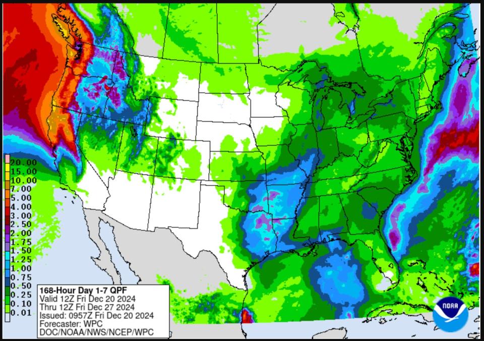
A parade of short-lived atmospheric rivers is forecast to drop 3 to 4 inches of rain in the Willamette Valley, and 5 to 7 inches of precipitation in the mountains and coast over the next seven days.
The most likely impacts at this point include:
-
Possible flooding of coastal rivers around or after Christmas
-
High winds and possible power outages, mostly at the Coast but also possibly the Willamette Valley, around Christmas
-
Possible snow on Cascade Mountain passes Christmas Eve, Christmas Day or just after Christmas Day. Total amounts or impact is unclear at this point.

This graphic shows the seven day precipitation outlook and includes a lot of rain for the Pacific Northwest.
It’s a weather system that doesn’t look as though it will bring massive and widespread disruption, at least at this point, but could bring some local complications, Alviz said.
Advertisement
Advertisement
For those interested in winter recreation, like skiing, the forecast isn’t ideal with rain mixed with snow even at the highest elevations.
“We’re going to make the most of it,” Hoodoo Ski Area general manager Matthew McFarland said. “We think we’ll get some snow up top and when it is raining that does mean very forgiving snow and typically short lines for the lifts. We’re also looking at a very nice present of snow on Christmas. So we’re still optimistic.”
Before leaving home to travel
Anyone leaving home to travel should check Tripcheck.com for road closures or hazards, and be prepared for winter driving conditions.
This weekend: rain in the valley and on Cascade passes
This weekend is forecast to be fairly wet just about everywhere, with over an inch of rian falling in the Willamette Valley and a few inches in the mountains.
Advertisement
Advertisement
The snow level is forecast to stay around 5,000 to 6,000 feet, and in some cases rising way up to 7,000 feet.
“That means minimal to no impact for the Cascade passes,” Alviz said. In other words, a decent time to travel over the mountains.
Early next week: somewhat of a break, then possible mountain snow
The precipitation lets up somewhat on Monday, offering a little bit of a break with light showers in the valleys. Monday should still be a good travel day, Alviz said.
On Tuesday, there is the possibility for light snow on the Cascade passes. At this point, it doesn’t appear likely to bring major impact.
“The roads may not be cold enough to accumulate snow, but people should still prepare for winter conditions and check Tripcheck.com before leaving home,” Alviz said.

A warning for drivers near the Santiam Junction during a winter storm warning and advisory on Halloween.
Christmas Day and after: Biggest impacts
The weather alerts start to mount Christmas Day and just after, with forecasts for high winds, mountain snow and rain.
Advertisement
Advertisement
More in Lifestyle
“We’ve got another front coming Christmas Day and really coming in Christmas Day night,” Alviz said.
Snow levels are forecast to drop to 3,000 to 3,500 and there would be “more snow with that system compared to the ones before it, although whether we’ll issue a warning or advisory remains to be seen,” he said. Check Tripcheck.com and the forecast for mountain passes before leaving home, he noted.
Impacted roads could include any over the Cascade Mountains, but particularly Highway 20 over Santiam Pass, Highway 58 over Willamette Pass and highways 138/62 in the Southern Cascades.
Winds and rain on the Coast
Winds could be high enough to knock out power at the Coast, and possibly in the Willamette Valley.
Advertisement
Advertisement
At the Coast and in the Coast Range, heavy rain could start leading rivers to rise. Currently, there’s a 15-30% chance of coastal rivers flooding, Alviz said, though that would most likely happen in the days after Christmas, later in the week.
Overall, the active weather will bring a number of potential hazards that may or may not end up having an impact. Anyone traveling should simply be prepared, Alviz said.
Winter recreation: wet to start off, but hopefully improving
The high snow level in the Cascade Mountains will bring a mixed bag for winter recreation. Ski areas will be open daily, and should have enough snow to stay open, but there is likely to be a mix of rain and snow particularly over this weekend and into early next week.
The highest-elevation ski areas like Mount Bachelor and Timberline Lodge will likely get more snow, with rain likely at lower elevation ski areas. Ski area officials are hoping the trend toward more snow arrives with Christmas.

Hoodoo Ski Area opened early this year, and will be open over the holiday break, but is likely to see some rain mixed with snow in the time period leading up to Christmas.
Lower elevation sno-parks — places where you can park with a sno-park permit to sled or snowshoe — will likely be very rainy, at places including Maxwell, Big Springs and Salt Creek sno-parks in the Central Cascades off Highways 22/20 and 58.
Advertisement
Advertisement
Better conditions may be possible on Christmas and after at sno-parks such as Santiam (for sledding) or Potato Hill (for snowshoeing).
To get a detailed forecast for the mountains, visit the NWS Portland page and type in locations such as “Santiam Pass” or “Willamette Pass” to see a detailed forecast for that elevation: https://www.weather.gov/pqr/.
Zach Urness has been an outdoors reporter in Oregon for 16 years and is host of the Explore Oregon Podcast. To support his work, subscribe to the Statesman Journal. He can be reached at zurness@StatesmanJournal.com or (503) 399-6801. Find him on Twitter at @ZachsORoutdoors.
This article originally appeared on Salem Statesman Journal: Oregon Christmas travel forecast: Wet, windy and high-elevation snow
EMEA Tribune is not involved in this news article, it is taken from our partners and or from the News Agencies. Copyright and Credit go to the News Agencies, email news@emeatribune.com Follow our WhatsApp verified Channel


