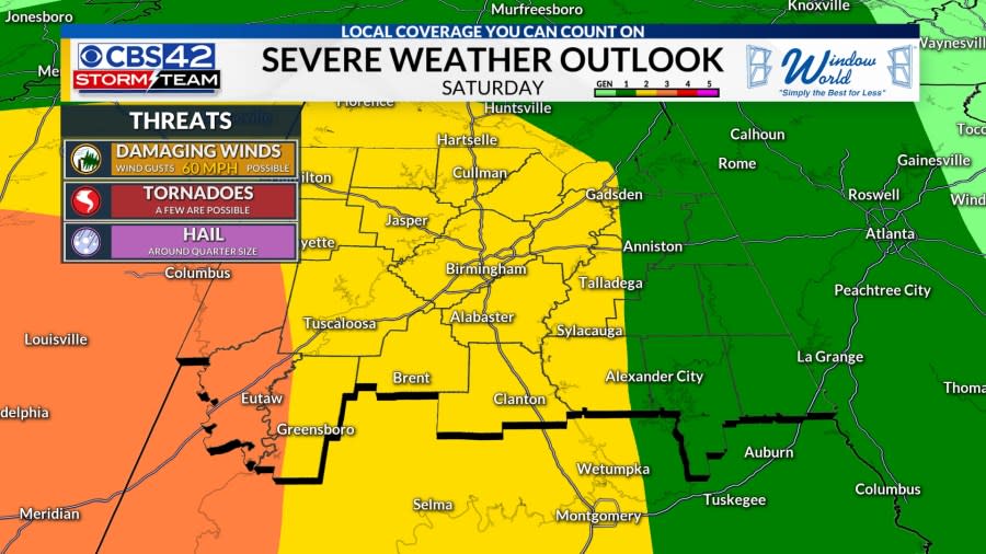
Weather Aware Saturday/Saturday Night: We’re watching a severe weather threat for the afternoon/evening hours on Saturday, lasting into the overnight and early Sunday as the storms track east and weaken with time. All modes of severe weather are possible with the greatest threat across western Alabama.

Tonight: Showers will become less numerous this evening and overnight, leaving us with overcast skies and temperatures holding steady in the mid/upper 50s.
Saturday: We need to all be weather aware during the afternoon and through early Sunday morning as strong to severe storms move across the entire region. Highs will reach the upper 60s Saturday afternoon with an increase in moisture, making it feel very sticky outside.

3 PM – 9 PM Saturday: Isolated strong to severe storms will form ahead of the cold front, posing the threat of producing damaging winds, large hail, and perhaps a brief tornado. The best tornado ingredients will arrive late Saturday evening and into the early overnight.
Advertisement
Advertisement
9 PM Saturday – 7 AM Sunday: This is when an organized strong to severe line of storms will quickly push out of Mississippi and into western Alabama first. This line will then sweep eastward, bringing torrential rainfall, the threat for damaging winds, and a brief tornado. For areas along and west of the I-65 corridor, your threat for severe storms will end shortly after midnight Saturday night. However, the line will take its time moving through eastern Alabama, causing the severe threat to linger into sunrise Sunday morning, impacting our far-eastern counties.

The best severe weather ingredients will reside over central/southern Mississippi and into west-central Alabama. As the storms push east, they will become weaker with time. Have multiple ways to receive warnings from Saturday afternoon into early Sunday. Be sure to download the CBS-42 App for weather alerts straight to your cellular device that is based on your current location.
Sunday: A shower may linger across eastern Alabama. Otherwise, the rest of the area will dry out with sunshine returning and highs reaching the middle 60s.
Next Week: Mild weather with highs in the 60s lasts through Tuesday before much cooler air filters in by New Year’s Day. Highs return to the low/mid 50s on Wednesday, becoming cooler through the end of next week as sunshine and dry weather prevails. Low temperatures will dip back to near freezing by Thursday and Friday mornings.

Advertisement
Advertisement
Be sure to follow the CBS 42 Storm Team:

Follow Us on Facebook: Chief Meteorologist Dave Nussbaum, Meteorologist Michael Haynes, Meteorologist Alex Puckett, and Meteorologist Jacob Woods.
Copyright 2024 Nexstar Media, Inc. All rights reserved. This material may not be published, broadcast, rewritten, or redistributed.
For the latest news, weather, sports, and streaming video, head to CBS 42.
EMEA Tribune is not involved in this news article, it is taken from our partners and or from the News Agencies. Copyright and Credit go to the News Agencies, email news@emeatribune.com Follow our WhatsApp verified Channel


