The Brief
-
A developing winter storm looms for parts of the Northeast later this week.
-
“Looks a little more significant than what we had just pass by, but it’s something to watch,” FOX 5 NY’s Mike Woods said.
-
Following this week’s event, another chance of snow arises for the weekend.
NEW YORK CITY – Residents across New York, New Jersey and Connecticut woke up to snow on the ground Monday morning, and according to forecasters, a more “significant” weather event is possible for later this week in New York City.
SNOW THIS WEEK: TIMELINE l NEXT CHANCE FOR NYC l WEEKEND EVENT? l RADAR
Developing winter storm
Timeline
According to the FOX Forecast Center, a low-pressure system will develop over the Plains by Tuesday, but will initially lack the moisture needed to strengthen.
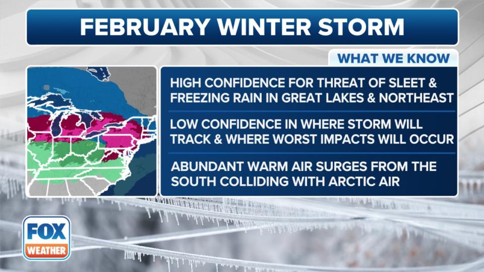
Here’s what we know about the February winter storm. (FOX Weather)
Forecasters said that as the future system moves off to the east, a strong, southerly jet stream will kick in, pulling in warm, moisture-rich air across the eastern half of the U.S.
Advertisement
Advertisement
That setup will create a well-defined warm front, separating the frigid air to the north from the record-breaking warmth swamping the South.
This graphic compares two scenarios regarding a potential ice threat this week. (FOX Weather)
The issue is that the warm air will move into an area with a shallow layer of subfreezing air near the surface. That’s when problems could arise.
Big picture view
The first scenario includes a stronger low-pressure system developing over the Plains, remaining the dominant system.
With that, a stronger jet stream pulls in warm, moist air, leading to more freezing rain in parts of the Northeast.
This graphic shows the forecast ice accretions this week. (FOX Weather)
With scenario two, a weaker low-pressure system would develop in the Plains, and a new coastal low would form along the East Coast and take over the dominant system.
This graphic shows the forecast rain totals this week. (FOX Weather)
Advertisement
Advertisement
A weaker low-level jet stream would mean less widespread freezing rain.
Snow on Thursday in NYC?
Local perspective
Here’s when New York City could see wintry weather this week, according to the National Weather Service.
-
Wednesday night: Snow before 4 a.m., then rain and sleet. The chance of precipitation is 90%.
Photo credit: The National Weather Service.
-
Thursday: Rain and sleet, becoming all rain after 7 a.m. The chance of precipitation is 90%.
Photo credit: The National Weather Service.
What they’re saying
“The next area of low-pressure comes by, that’s the one with that interesting wintry mix that wants to come through late Wednesday into Thursday,” FOX 5 NY’s Mike Woods said. “Looks a little more significant than what we had just pass by, but it’s something to watch, and it’s still a few days away.”
What we don’t know
Computer forecast models still disagree on the storm’s track and on whether it moves east, as expected at this time, or if a new coastal low develops along the East Coast.
More snow this weekend?
What’s next
Following Thursday’s event, another round of snow looms for the weekend.
Advertisement
Advertisement
More in U.S.
-
Saturday: A 30% chance of snow.
-
Saturday night: Rain, snow, and sleet likely. The chance of precipitation is 70%.
-
Sunday: Rain likely. The chance of precipitation is 60%.
“Another wintry mix comes through on Saturday,” Woods said. “That one might be a little more significant.”
NYC weather radar
Click HERE for more information.
EMEA Tribune is not involved in this news article, it is taken from our partners and or from the News Agencies. Copyright and Credit go to the News Agencies, email news@emeatribune.com Follow our WhatsApp verified Channel


