A typhoon moving into China on Thursday unleashed severe flooding this week, killing more than a dozen people in the Philippines and Taiwan. According to Reuters, the typhoon, named Gaemi by Japan’s Meteorological Agency and Carina by the Philippines weather service, was the strongest to hit Taiwan in eight years.
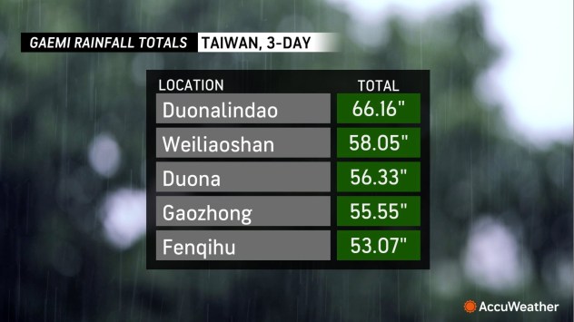
Rain from the typhoon in Taiwan was extreme, with feet of rain falling in the mountains. As of Thursday evening, 66.16 inches of rain (5.51 feet) had fallen in the last three days at Duonalindao, with 58.05 inches at Weiliaoshan.
Taiwan’s financial markets, government offices and schools remained closed on Thursday. A cargo ship carrying nine people sank 20 miles off the coast of Taiwan on Thursday in rough seas, the fire agency reported.
Although it did not directly impact the Philippines, moisture from the Typhoon caused extreme flooding in the archipelago, where more than a dozen people have already been killed, according to The Associated Press. The Philippine Coast Guard reported being overwhelmed with flood rescue requests for residents in the capital city of Manila. Footage from Quezon City, Philippines, Wednesday showed barges hitting a bridge on a flooded river.
 |
The Philippine Coast Guard said an oil tanker carrying over 1,000,000 liters of oil capsized off the coast of Bataan earlier in the day. The Coast Guard was monitoring a 2.3-mile-long oil spill associated with the accident.
Severe Tropical Storm Gaemi is the equivalent of a Category 1 hurricane on the Saffir-Simpson Hurricane Wind Scale and is pushing into the Fujian province of China Thursday evening.
 |
Gaemi will continue to produce areas of heavy rain across China’s Zhejiang, Fujian and eastern Guangdong provinces into Saturday, local time. Rain will spread northward reaching Henan, Shandong, Shanxi and Hebei provinces in China from Saturday night into Monday, local time. Rainfall totals will be up to 24 inches (600 mm) in Taiwan and Fujian into southern Zhejiang provinces of China with an AccuWeather Local StormMax™ of 36 inches (900 mm), which will lead to flooding, mudslides and extended transportation and logistical delays.
 |
Interaction with Taiwan caused Gaemi to lose wind intensity, but wind gusts to 120 mph (190 km/h), with an AccuWeather Local StormMax™ of 170 mph (270 km/h) are expected along the Fujian coast of China near the center of the storm. This is expected to lead to power outages and structural damage. In eastern China, damaging wind gusts can reach as far north as the Yangtze River Valley from Friday into the weekend.
Earlier this week, Typhoon Gaemi was a Category 4 equivalent on the Saffir Simpson Hurricane Scale. On Wednesday, the typhoon performed a loop in its track, approaching the coast of Taiwan before grazing the coast and moving east, then turning around and making landfall just before midnight as a Category 3. The looping phenomenon is caused by interaction with the mountains in Taiwan and is not unusual for storms in the area, AccuWeather Lead International Expert Jason Nichols says.
“The loop in Gaemi’s track is due to being deflected off the mountainous coast of Taiwan due to orographic blocking, causing an asymmetric flow over the center of the typhoon,” Nichols explained. Eventually, the storm resumes something similar to its previous trajectory.
 |
|
Taiwan weather radar loop showing Typhoon Gaemi 7 a.m. Wednesday to 2 a.m. Thursday local time. (Central Weather Administration) |
Other than Gaemi, a tropical low, known as Invest 95W, is forming near Palau. Conditions may allow this feature to strengthen gradually as it tracks northwestward over the next few days. There is only a minimal chance for development into a tropical depression or storm early next week. Upwelling in the wake of Gaemi will likely help inhibit the formation of a significant tropical system.
EMEA Tribune is not involved in this news article, it is taken from our partners and or from the News Agencies. Copyright and Credit go to the News Agencies, email news@emeatribune.com Follow our WhatsApp verified Channel


