Hurricane Sara, currently designated as Invest 99L, is expected to form this week and head northwest − toward Florida − by the middle of next week, according to the latest information from AccuWeather.
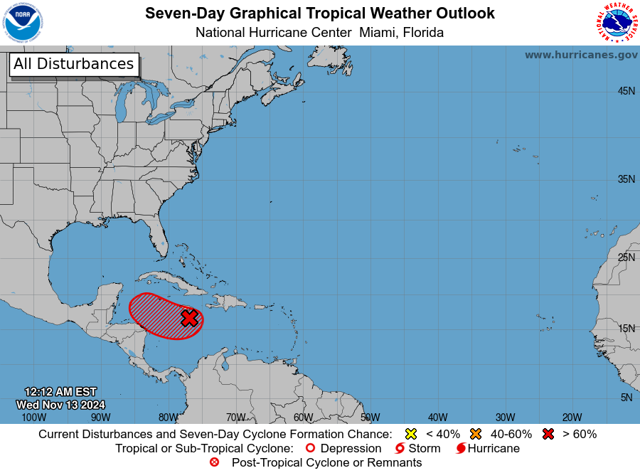
The National Hurricane Center increased the likelihood of Tropical Storm Sara forming to 90% over the next two days before it’s expected to intensify into a hurricane.
AccuWeather published an early Hurricane Sara timeline that shows the storm could make landfall in South Florida by Wednesday.
Advertisement
Advertisement
“Wind shear remains low over much of the Caribbean, and waters are plenty warm (in the 80s F),” AccuWeather Chief On-Air Meteorologist Bernie Rayno said.
“And now, with showers and thunderstorms beginning to gather, it will likely not be much longer until the tropical rainstorm continues to organize into a tropical storm.”

Seven-day graphical tropical forecast as of Wednesday morning, Nov. 13. 2024.
Like other hurricanes that have spawned out of the Caribbean Sea this year, conditions could allow for Sara to rapidly intensify, shooting up from a fledgling storm into a major hurricane over just a few days.
“There are multiple scenarios with the feature in the Caribbean that are tied to the speed of development and track early on that could affect land areas with landfall and direct impacts later on,” AccuWeather Lead Hurricane Expert Alex DaSilva said.
Advertisement
Advertisement
“Not only does this have a high chance of becoming a hurricane by the end of this week, but it may become a major hurricane very quickly − this weekend.”
While the 2024 Atlantic hurricane season got off to a slow start during an uncharacteristic lull early on, the back end of the season has indeed been supercharged.
A typical season sees around seven hurricanes. Sara will mark the 12th hurricane of the season and has the potential to become the sixth major hurricane.
When will we see Tropical Storm and Hurricane Sara?
The National Hurricane Center predicts that Tropical Storm Sara has a high chance of forming over the next 48 hours. Afterward, AccuWeather suspects that the storm will rapidly intensify.
Advertisement
Advertisement
More in U.S.
“The potential exists for the rainstorm to intensify into a hurricane as early as Friday morning,” AccuWeather wrote in its latest update. “Further intensification is expected after that, and a Category 3 major hurricane (maximum sustained winds of 111 mph or greater) is likely to be churning in the western Caribbean this weekend.”
Hurricane Sara expected to carve a path toward Florida

AccuWeather has predicted an early track for a fledgling Hurricane Sara. There remains plenty of uncertainty on the track this far out.
Right now, conditions suggest that the system will move slowly westward into the western Caribbean Sea before it turns northwest by early next week and potentially hooking northeast by mid-week.
AccuWeather published an early timeline that shows Sara rapidly intensifying from a tropical storm into a Category 3 hurricane between Friday and Saturday as it moves straight west.
The storm will begin its hook northwest around Saturday afternoon. From there, Sara will maintain its major hurricane status as it treks north-northwest through Tuesday morning. AccuWeather expects the storm to turn northeast toward Florida’s Gulf Coast Tuesday afternoon.
How will Hurricane Sara impact Florida?
Exactly how Florida could be impacted by Hurricane Sara is still being assessed. Present data indicates that South Florida has the highest chance of seeing at least some impact.
Advertisement
Advertisement
A major hurricane would bring torrential downpours, flash flooding and strong gusts of wind. Any impacted area can anticipate some property damage and power outages. Strong storm surge will also pose significant risk to lives and property.
Sara storm track
There are two possible scenarios that could result in Hurricane Sara hitting Florida in some capacity, and it all depends on a dome of high pressure along the southern Atlantic Coast of the United States.
If the pressure moves away quickly enough and its trailing cold front follows suit, we will see a stronger Hurricane Sara that will have a greater impact on Florida, according to AccuWeather. Steering breezes could guide the system toward the Florida Keys and the southern part of the Florida Peninsula.
If the pressure holds its ground and the subsequent cold front arrives a bit slower, it will steer Sara into Central America or southeastern Mexico later this weekend and into next week. Afterward, Sara could wane over that area or take a turn toward the Gulf of Mexico.
Advertisement
Advertisement
The longer Sara spends over land in the second scenario, the greater the odds are that the storm loses enough wind intensity to prevent it from becoming a hurricane again before it approaches the Florida Peninsula or possibly the Florida Panhandle.
Rafael continues to impact area beaches along the Florida Panhandle
The remnants of Hurricane Rafael continue to bring life threatening rip currents and high surf to the Florida Panhandle.
Residual swells from the storm are still present in the Gulf and will continue to cause locally rough surf and strong rip currents from Pensacola Beach to Panama City.
AccuWeather says that Rafael’s remnants will continue to loop around the western and central Gulf over the next few days, but wind shear will also continue shredding what’s left of Rafael’s circulation and moisture.
Advertisement
Advertisement
“We believe that some or the bulk of Rafael’s remaining moisture will be drawn northward into the central Gulf Coast region around the middle of the week as yet another non-tropical feature − a cold front moves from west to east over the lower Mississippi Valley,” AccuWeather Meteorologist Grady Gilman said.
Pensacola area weather for the week of Nov. 11-17
The Pensacola area can expect to see a wet week followed by cooler, dryer conditions. Temperatures will fluctuate with highs in the 70s-80s and lows from the mid-50s to upper 40s as we get closer to the end of the week, according to the National Weather Service Office Mobile/Pensacola.
-
Wednesday, Nov. 13 — There’s a 50% chance of showers after 3 p.m. on Wednesday. Skies are mostly cloudy with a high near 77. It will be breezy, with an east wind blowing 15 to 20 mph and gusts up to 30 mph. Wednesday night will see showers and a possible thunderstorm. The low will be around 70.
-
Thursday, Nov. 14 — There will be a 20% chance of showers and thunderstorms before 9 a.m. It will be mostly cloudy before conditions clear up, with a high near 77. There will be a south wind round 10 mph becoming north in the afternoon. Temperatures will drop to around 53 by Thursday night.
-
Friday, Nov. 15 — Friday will be mostly sunny with a high near 71 and a low around 52.
-
Saturday, Nov. 16 — Saturday will be sunny with a high near 74 degrees and a low near 57.
-
Sunday, Nov. 17 — Sunday will also be sunny with a high near 76 degrees and a low near 61.
-
Monday, Nov. 18 — Monday will be mostly clear, with a high near 77 degrees and a low around 66.
-
Tuesday, Nov. 19 — There’s a 20% chance of showers on Tuesday, but most of the area will be partly sunny. The high will be near 78 degrees.
Pensacola Beach weather and flags
Pensacola Beach will see moderate to high rip currents through Friday, according to the National Weather Service Office Mobile/Pensacola.
-
Current flag conditions at Pensacola Beach: Double red flag
-
Current Water temperature: 76 degrees.
-
Tomorrow’s beach flag forecast: 40% red flag, 60% double red flag
Pensacola Beach rip current forecast:
Advertisement
Advertisement
-
Tuesday: Moderate — Life threatening rip currents are possible. Beachgoers should swim near a lifeguard and heed the advice of local beach patrol and flag warnings.
-
Wednesday: High — Life threatening rip currents are likely. The surf is dangerous for all levels of swimmers.
-
Thursday: High
-
Friday: Moderate
Editor’s note: This story was updated to include the National Hurricane Center’s latest designation for the storm and include spaghetti models.
This article originally appeared on Pensacola News Journal: Hurricane Sara expected to form this week, target Florida
EMEA Tribune is not involved in this news article, it is taken from our partners and or from the News Agencies. Copyright and Credit go to the News Agencies, email news@emeatribune.com Follow our WhatsApp verified Channel


