 |
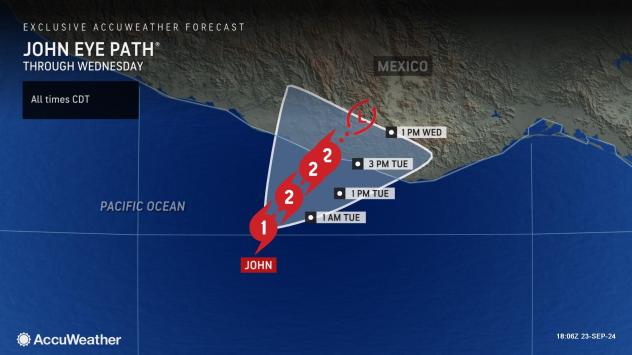
Hurricane John, located over the eastern Pacific Ocean, has the potential to intensify rapidly into a major hurricane before making landfall in south-central Mexico with life-threatening conditions and catestrophic damage, AccuWeather meteorologists warn.
The combination of slow movement and ramp-up of the hurricane around landfall can be very dangerous.
 |
Near and just east of where the eye moves ashore in south-central Mexico, a storm surge of 6-10 feet is anticipated but could be higher if the hurricane strengthens quickly prior to landfall.
“John is a slow-moving hurricane, but has a lot of upside potential before moving onshore along the Pacific coast of Mexico late Tuesday and lingering effects well after landfall,” AccuWeather Hurricane Expert Alex DaSilva said.
 |
While the major city of Acapulco, Mexico, may dodge John’s worst impacts, the cities of Puerto Angel and Puerto Escondido are likely to be hit hard.
“The hurricane will have the impact of a 3 or possibly a 4 on the Accuweather RealImpact™ Scale for Hurricanes,” DaSilva said, “While the storm will lose wind intensity shortly after landfall, it may stall and continue to wring out tremendous amounts of rain in the vicinity.”
 |
AccuWeather’s RealImpact scale factors include storm surge, flooding rainfall, economic impacts, population affected, and damaging winds. The Saffir-Simpson hurricane scale only rates a hurricane’s intensity based on sustained winds.
The exact intensity of the hurricane at landfall will determine the RealImpact scale, but because of the excessive rainfall potential with life-threatening flash flooding and mudslides, the RealImpact will likely be at least one level higher than the Saffir-Simpson scale.
 |
“John will easily unload 8-16 inches of rain on the steep terrain, but there is an AccuWeather Local StormMax™ rainfall of 50 inches,” DaSilva said, “That can lead to catastrophic flooding.”
Want next-level safety, ad-free? Unlock advanced, hyperlocal severe weather alerts when you subscribe to Premium+ on the AccuWeather app. AccuWeather Alerts™ are prompted by our expert meteorologists who monitor and analyze dangerous weather risks 24/7 to keep you and your family safer.
EMEA Tribune is not involved in this news article, it is taken from our partners and or from the News Agencies. Copyright and Credit go to the News Agencies, email news@emeatribune.com Follow our WhatsApp verified Channel


