


Remnants of Tropical Storm Beryl could reach the Louisville metro area by Tuesday, the National Weather Service said in a statement Sunday. Heavy rain and winds could result in “isolated strong to severe storms.”
NWS Louisville said much of Kentucky, expect for the far eastern part of the state, is under a “slight risk” for severe weather Tuesday. The slight risk area also includes several counties in southern Indiana.
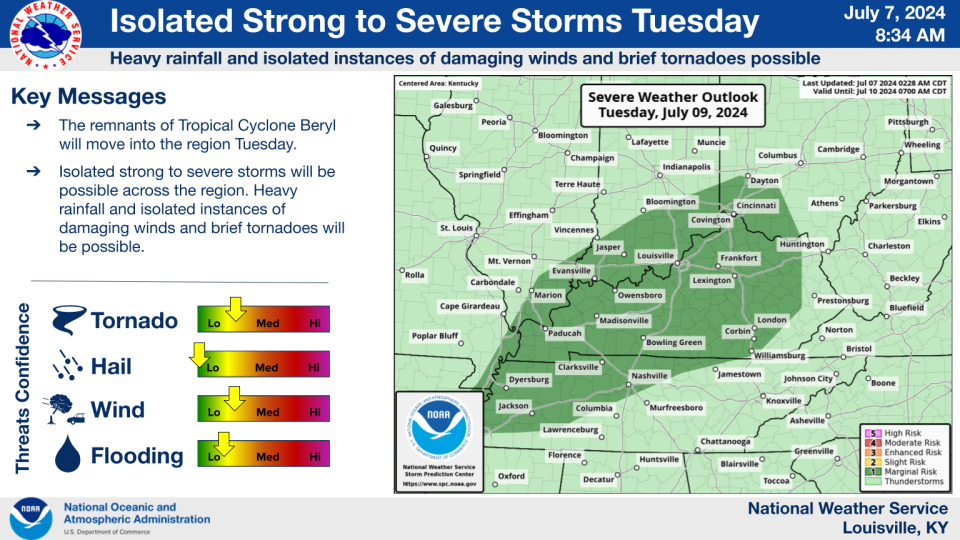
Cities just outside of the area were at risk for non-severe thunderstorms, according to a graphic from the National Weather Service issued Sunday morning.
Tropical Storm Beryl, which made landfall as a hurricane in Jamaica and Mexico over the July Fourth weekend, is expected to reach the Texas coast early Monday morning, USA TODAY reported. On Sunday, the National Hurricane Center anticipated the storm would weaken into a tropical depression while traveling northeast through Texas, Arkansas and Missouri.
How likely is Beryl’s arrival in Louisville?
Louisville was just south of the USA TODAY storm tracker’s cone Sunday afternoon, but there is a 33% chance Beryl’s path could veer outside the projection, according to the map.
“The track may continue to shift in the coming days which would impact the placement of the heaviest rainfall,” the National Weather Service in Paducah said in a statement Sunday. The weather service’s office in Paducah serves parts of western Kentucky and Indiana.
None of the computer models used by the National Weather Service showed the path of the storm going through Louisville directly.
How much rain could Louisville get Tuesday?
Louisville could receive more than a half-inch of rain Tuesday, according to a forecast from the National Weather Service. Locally residents could see higher amounts.
There is a 50% chance of rain during the day and a 60% of rain overnight Tuesday, according to the NWS forecast. Thunderstorms are possible throughout the day.
What are the chances for tornadoes in Louisville?
The National Weather Service in Louisville stated “brief tornadoes” could occur in the region Tuesday.
“The strongest storms will be capable of producing heavy rainfall and isolated instances of damaging winds and brief tornadoes,” NWS Louisville said in a statement Sunday.
Multiple tornadoes have touched down in Louisville this year, as recently as Thursday, when an EF-1 tornado damaged homes and cars in the West End. In April, a tornado crossed the Ohio River into Prospect.
Louisville 5-day forecast
Sunday night: Mostly clear, with a low around 67. Calm wind.
Monday: Mostly sunny and hot, with a high near 94. Calm wind.
Monday night: Mostly cloudy, with a low around 73. Light west wind.
Tuesday: A chance of showers, with thunderstorms also possible after 11 a.m. Mostly cloudy, with a high near 90. Calm wind becoming west around 5 mph in the afternoon. Chance of precipitation is 50%. New rainfall amounts of less than a tenth of an inch, except higher amounts possible in thunderstorms.
Tuesday night: Showers likely and possibly a thunderstorm. Mostly cloudy, with a low around 73. Chance of precipitation is 60%. New rainfall amounts between a quarter and half of an inch possible.
Wednesday: Showers likely and possibly a thunderstorm before 2pm, then a chance of showers and thunderstorms after 2 p.m. Partly sunny, with a high near 83. Chance of precipitation is 60%.
Wednesday night: A chance of showers and thunderstorms before 2 a.m., then a slight chance of showers. Partly cloudy, with a low around 68. Chance of precipitation is 30%.
Thursday: A slight chance of showers, then a chance of showers and thunderstorms after 2 p.m. Mostly sunny, with a high near 85. Chance of precipitation is 30%.
Thursday night: A 30 percent chance of showers and thunderstorms before 8 p.m. Partly cloudy, with a low around 68.
Friday: Mostly sunny, with a high near 90.
More: Honeymoon now a ‘prison nightmare,’ after Hurricane Beryl strands couple in Jamaica
Reach reporter Leo Bertucci at lbertucci@gannett.com or @leober2chee on X, formerly known as Twitter
This article originally appeared on Louisville Courier Journal: Tropical Storm Beryl: Louisville could be in path of former hurricane
EMEA Tribune is not involved in this news article, it is taken from our partners and or from the News Agencies. Copyright and Credit go to the News Agencies, email news@emeatribune.com Follow our WhatsApp verified Channel


