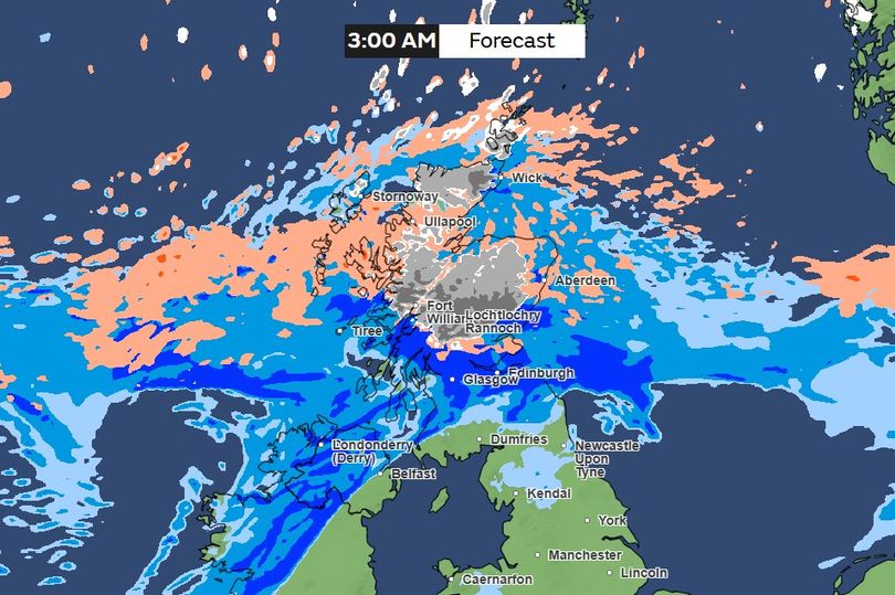
Snow is expected to hit the UK as 2024 rolls into 2025, with some parts of the country expected to see a white New Year’s Day, according to the latest weather maps.
The Met Office’s long-range forecast from December 30 to January 8 warns of colder air moving southwards, heightening the likelihood of sleet and snow as the New Year begins. The forecast states: “As colder air from the north progresses southwards, the risk of sleet and snow increases, especially in northern areas, but this will depend each day on where the thermal boundary lies.”
The forecaster’s map shows that early New Year’s Day will spell snow for the north of Scotland, including Fort William, Loch Rannoch and Pitlochry.
ADVERTISEMENT
READ MORE: How much each council in Greater Manchester spends on Christmas lights
READ MORE: Boxing Day weather in Greater Manchester for your post-Christmas walk
According to forecasters, temperatures are expected to start around average but will dip below average for most areas, particularly in the north, although occasional milder spells may still occur in the south. However, the Met Office notes that while there is moderate to high confidence in this trend, the exact positioning of weather systems, which will determine which areas experience rain or snow, is uncertain.
This follows the Met Office’s earlier prediction that the milder weather seen around Christmas would likely give way to cooler and rainier conditions in the New Year. Meteorologist Tom Morgan stated: “As we move towards the New Year, we could see a change to cooler conditions and wetter conditions more widely.”
He added that while the likelihood of snow is increasing, it’s currently unclear exactly when and where it will fall, saying: “There could be some heavy rain at times and there is an increasing chance of some snow – but it’s too early to say where that snow is going to fall.”
ADVERTISEMENT
Forecasts become difficult after the New Year, as it’s too early to tell exactly what the weather patterns will be. At the moment, the Met Office says: “Confidence in this period is fairly low, but continuing from the previous period, there remains a chance of rather unsettled and cool conditions continuing at first, with the wettest conditions perhaps focussed more over the south (still with a risk of snow on the northern edge), with sleet and snow showers further north.
“Then, through the rest of January, something more climatological could return with the wettest and coolest conditions further north, and with higher pressure further south, it is more likely to be drier, and at times milder here than elsewhere.”
EMEA Tribune is not involved in this news article, it is taken from our partners and or from the News Agencies. Copyright and Credit go to the News Agencies, email news@emeatribune.com Follow our WhatsApp verified Channel


