

The first week of September has arrived, and with it comes more activity in the tropics, especially tropical waves that have more potential for development.
The National Hurricane Center is tracking two tropical waves. Both have a 40 percent chance of developing over the next seven days and could become tropical depressions later this week or over the weekend.
➤ Weather alerts via text: Sign up to get updates about current storms and weather events by location
The tropical waves the Hurricane Center highlighted on its tropical outlook map are located:
Historically, about two-thirds of all Atlantic hurricane activity occurs between Aug. 20 and Oct. 10, said Philip Klotzbach, meteorologist at Colorado State University specializing in Atlantic basin seasonal hurricane forecasts.
Labor Day 2024 unusual for the tropics
AccuWeather forecasters said Labor Day weekend typically is one of the busiest times in the tropics. The most active period of the Atlantic hurricane season runs from mid-August to mid-October, with the peak arriving Sept. 10.
This year marked the first time in 27 years a named tropical storm did not develop in the Atlantic basin between Aug. 21 and Sept. 2, AccuWeather said.
Expect tropical activity to ramp up

Wind shear, which has helped prevent tropical waves from organizing, is expected to lessen by the middle of September.
Along with the transition to La Niña conditions and reduction in the amount of Saharan dust, forecasters are expecting tropical activity to increase this month.
The next named storm of the season will be Francine.
Here’s the latest update from the NHC as of 2 a.m., Sept. 3:
What’s out there and how likely are they to strengthen?

Caribbean Sea: Disorganized showers and thunderstorms continue in association with a westward-moving tropical wave located over the eastern Caribbean Sea.
Environmental conditions are expected to become more conducive for development when the system reaches the western Caribbean Sea and southwestern Gulf of Mexico late this week, and over the weekend, and a tropical depression could form during that time.
-
Formation chance through 48 hours: low, near 0 percent.
-
Formation chance through seven days: medium, 40 percent.
Eastern Tropical Atlantic Ocean: A tropical wave over the far eastern Atlantic is producing disorganized showers and thunderstorms.
Environmental conditions are forecast to become a little more conducive for development, and a tropical depression could form in a few days while the disturbance moves slowly west-northwestward or northwestward over the easterntropical Atlantic Ocean.
This system could produce locally heavy rains and gusty winds across portions of the Cabo Verde Islands in a day or two.
-
Formation chance through 48 hours: low, 10 percent.
-
Formation chance through seven days: medium, 40 percent.
Tracking tropical waves? Here’s latitude, longitude of where they are

-
Eastern Atlantic: An eastern Atlantic tropical wave is near 23W from 19N southward across the eastern Cabo Verde Islands, and moving west at 17-23 mph.
-
Central Atlantic: A central Atlantic tropical wave is near 38W from 19N southward, and moving west around 17 mph. Scattered moderate to isolated strong convection is found from 12N to 16N between 38W and 42W.
-
Eastern Caribbean: An eastern Caribbean tropical wave is near 67W from 20N southward across Puerto Rico to northern Venezuela. It is moving west at 23 mph. Widely scattered moderate convection is present at the eastern Caribbean Sea.
What do the colored areas on the NOAA map mean?
The hatched areas on a tropical outlook map indicate “areas where a tropical cyclone — which could be a tropical depression, tropical storm or hurricane — could develop,” said National Hurricane Center Deputy Director Jamie Rhome.
The colors make it visibly clear how likely a system could develop with yellow being low, orange medium and red high.
The National Hurricane Center generally doesn’t issue tropical advisories until a there is a named storm, but there is an exception.
“If a system is near land and there is potential for development, the National Hurricane Center won’t wait before it issues advisories, even if the system hasn’t become an actual storm. This gives residents time to prepare,” Rhome said.
Who is likely to be impacted?

The National Hurricane Center said the tropical wave could cross the Yucatan Peninsula and enter the Bay of Campeche over the weekend, bringing showers and thunderstorms to portions of the southwestern Gulf of Mexico.
It’s too early at this time to determine if there will be any impact to Florida or the U.S. but AccuWeather forecasters warned near-record water temperatures brings a potential for rapid intensification of any named storm that forms. Residents along the Gulf should watch the system closely.
It’s still too early to determine if there will be any impacts to Florida from the tropical wave in the eastern Atlantic.
Forecasters urge all residents to continue monitoring the tropics and to always be prepared. That advice is particularly important for what is expected to be a very active hurricane season.
Weather watches and warnings issued in Florida
When is the Atlantic hurricane season?
The Atlantic hurricane season runs from June 1 through Nov. 30.
The Atlantic basin includes the northern Atlantic Ocean, Caribbean Sea and Gulf of Mexico.
Stay informed. Get weather alerts via text
When is the peak of hurricane season?
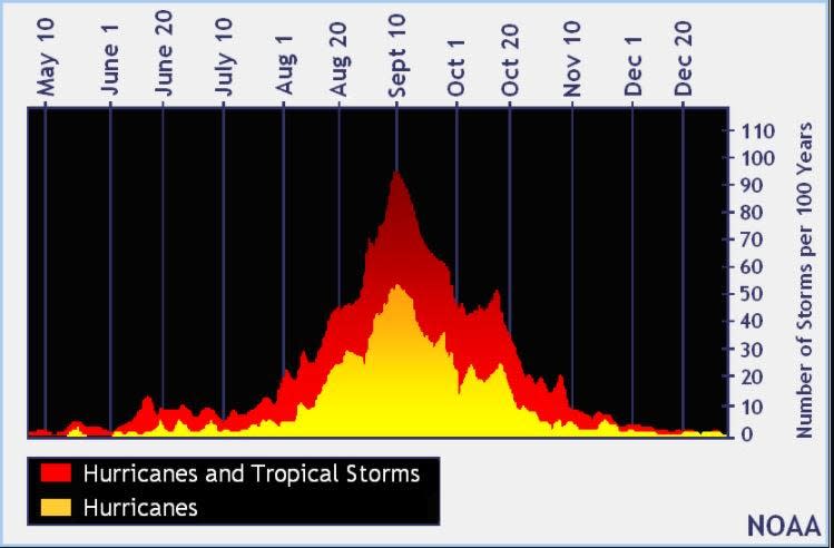
The peak of the season is Sept. 10, with the most activity happening between mid-August and mid-October, according to the Hurricane Center.
National Hurricane Center map: What are forecasters watching now?
Systems currently being monitored by the National Hurricane Center include:
Interactive map: Hurricanes, tropical storms that have passed near your city
Excessive rainfall forecast
What’s next?
We will continue to update our tropical weather coverage daily. Download your local site’s app to ensure you’re always connected to the news. And look for our special subscription offers here.
This article originally appeared on Treasure Coast Newspapers: Tropics update: NHC tracking 2 systems, tropical depressions possible
EMEA Tribune is not involved in this news article, it is taken from our partners and or from the News Agencies. Copyright and Credit go to the News Agencies, email news@emeatribune.com Follow our WhatsApp verified Channel


