


There is a high risk of another tropical storm or hurricane forming in the Gulf of Mexico this week, forecasters say. The U.S. could see impacts from the development.
“Conditions remain ripe for tropical development in the western Caribbean and the Gulf of Mexico over the next week and steering breezes would tend to guide any feature that forms in those waters toward the United States,” according to AccuWeather.
Those sentiments were echoed Sunday by Dr. Ryan Truchelut, chief meteorologist with WeatherTiger.
“Traumatized” Gulf Coast, Florida and the Southeast need to keep a close eye on this potential threat. Truchelut is a Florida meteorologist who works with the USA TODAY Network.
In a telephone interview Friday, AccuWeather Chief Meteorologist Jonathan Porter warned residents along the Gulf Coast to not “let your guard down” as a system of low pressure could form over the western Caribbean.
➤ Weather alerts via text: Sign up to get updates about current storms and weather events by location
Here’s what we know from the National Hurricane Center’s latest advisory.
NHC tracking tropical disturbance moving towards Gulf of Mexico
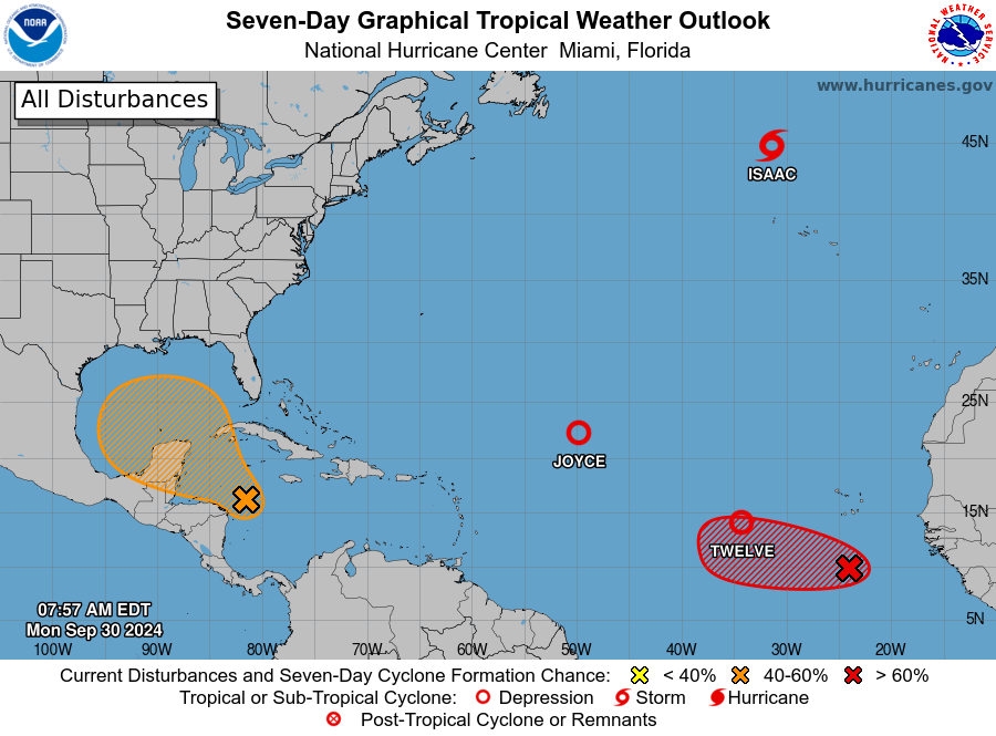
A broad area of low pressure located over the western Caribbean Sea is producing disorganized showers and thunderstorms.
Environmental conditions appear conducive for gradual development, and a tropical depression could form around the middle part of this week while the disturbance moves slowly west-northwest.
This system is then expected to move northwestward into the Gulf of Mexico during the latter portion of this week.
Residents in the northwestern Caribbean Sea and along the U.S. Gulf Coast should monitor the progress of this system.
-
Formation chance through 48 hours: Low, near 0 percent.
-
Formation chance through 7 days: Medium, 40 percent.
TIMELINE: When could a tropical depression or storm develop?
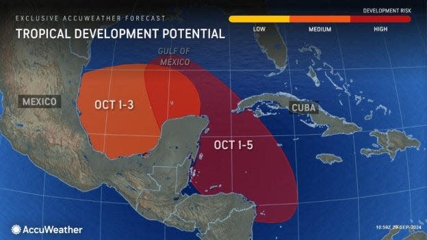
AccuWeather meteorologists said the area from the western Caribbean to the Gulf of Mexico will remain a potential tropical development zone into the first half of October.
“Over the next week, one to two tropical storms could be born in this zone and possibly steered across part of the southeastern United States that was hit hard by Hurricane Helene.”
The National Hurricane Center said a tropical depression could form around the middle part of this week.
“At this range and without an actual disturbance to watch, I’d simply say that it’s perhaps a little more likely than not something eventually develops in the Caribbean in the next 4 to 8 days, though not a certainty,” Truchelut said Sunday.
“That is of course concerning, as a steering ridge over the western Atlantic would again mean anything that does develop is probably heading northwest into the Gulf by the end of the week.”
Tropics update: Will Texas be impacted?
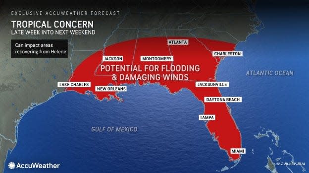
Downpours can be strewn anywhere from Louisiana to Florida, Georgia and the Carolinas in the U.S., according to AccuWeather.
As southwesterly breezes increase, they will tend to cause moisture, and any tropical feature that has formed or is trying to form will be guided to the north or east later next week into the following weekend.
If those steering breezes remain weak, then a track toward Louisiana could occur, said AccuWeather.
If there are strong steering breezes from the southwest occur, then a track toward Florida and perhaps the coastal areas of Georgia and the Carolinas would be more likely.
The most likely scenario with this week’s tropical feature is that it will get drawn northward to a point over the Gulf but then shunted northeastward late this week, AccuWeather said.
Hurricane tracker: NHC tracking 3 active storms, 1 tropical disturbance in the Atlantic
In addition to the system developing over the western Caribbean Sea, the NHC is watching a trio of active storms in the Atlantic:
-
Tropical Storm Isaac: Several hundred miles north of the Azores.
-
Tropical Depression Joyce: Central Atlantic Ocean.
-
Tropical Depression Twelve: Eastern Tropical Ocean.
What do the colored areas on the NOAA map mean?
The hatched areas on a tropical outlook map indicate “areas where a tropical cyclone — which could be a tropical depression, tropical storm or hurricane — could develop,” said National Hurricane Center Deputy Director Jamie Rhome.
The colors make it visibly clear how likely a system could develop with yellow being low, orange medium and red high.
The National Hurricane Center generally doesn’t issue tropical advisories until there is a named storm, but there is an exception.
“If a system is near land and there is potential for development, the National Hurricane Center won’t wait before it issues advisories, even if the system hasn’t become an actual storm. This gives residents time to prepare,” Rhome said.
It’s too early at this time to determine if there will be any impact to Texas or the U.S. from the other disturbances out there.
Forecasters urge all residents to continue monitoring the tropics and to always be prepared. That advice is particularly important for what is expected to be a very active hurricane season.
Texas weather watches and warnings
Stay informed. Get weather alerts via text
Interactive map: Hurricanes, tropical storms that have passed near your city
— USA TODAY reporter Cheryl McCloud contributed to this report.
This article originally appeared on Austin American-Statesman: NHC still tracking system near Gulf of Mexico. Will it impact Texas?
EMEA Tribune is not involved in this news article, it is taken from our partners and or from the News Agencies. Copyright and Credit go to the News Agencies, email news@emeatribune.com Follow our WhatsApp verified Channel

