Morgan Palmer – 9:42 p.m.
We have had some vigorous showers of snow and rain/snow mix this Sunday and even three reports of “thundersnow” from especially strong snow squalls — two in Whatcom County and also a lightning strike near Burien. In addition, there was at least one waterspout sighted off Birch Bay in the waters off Whatcom County earlier today.
As the atmosphere stabilizes somewhat into the overnight, we’re seeing the expected decrease in coverage and intensity of snow showers, but we’ll continue to have some periods of light now overnight, as well as some heavier snow in parts of Whatcom County and near the coast.
A Winter Weather Advisory continues for all locations in the lowlands except for coastal King, Snohomish counties and Island County. In these spots, any accumulation should be very minimal. In other spots, isolated 1-2 inch snow is possible.
Advertisement
Advertisement
Even in spots that don’t have snow tonight and into Monday morning, there will be some icy patches on roads from freezing water or snowmelt. Drivers should be especially careful early Monday on untreated, side roads and residential streets. It’s expected that main roads should remain fairly good, particularly treated roadways.
Morning lows will be in the 20s. In western Whatcom County, gusty winds out of British Columbia will force wind chills into the single digits early Monday.
While there could still be some spotty snow showers later on Monday morning, it’ll likely be drier in most areas with some breaks of sunshine. Highs will be in the 30s to near 40.
Another round of light snow is possible Monday evening into Monday night. Any accumulations should be minimal but won’t melt until later Tuesday.
Advertisement
Advertisement
There are chances for spotty flurries or a few very light snow showers Tuesday through Wednesday, though it’s expected to not be of any significance for most of the area based on present forecast data. The mountains could pick up some light accumulations. We’ll be watching the week’s forecast details closely as they evolve, as any additional moisture sent our way could increase snow chances some. But for now, it’s looking mainly dry though the week with just some flurries at times through Wednesday.
KIRO 7 News Staff – 9:04 p.m.
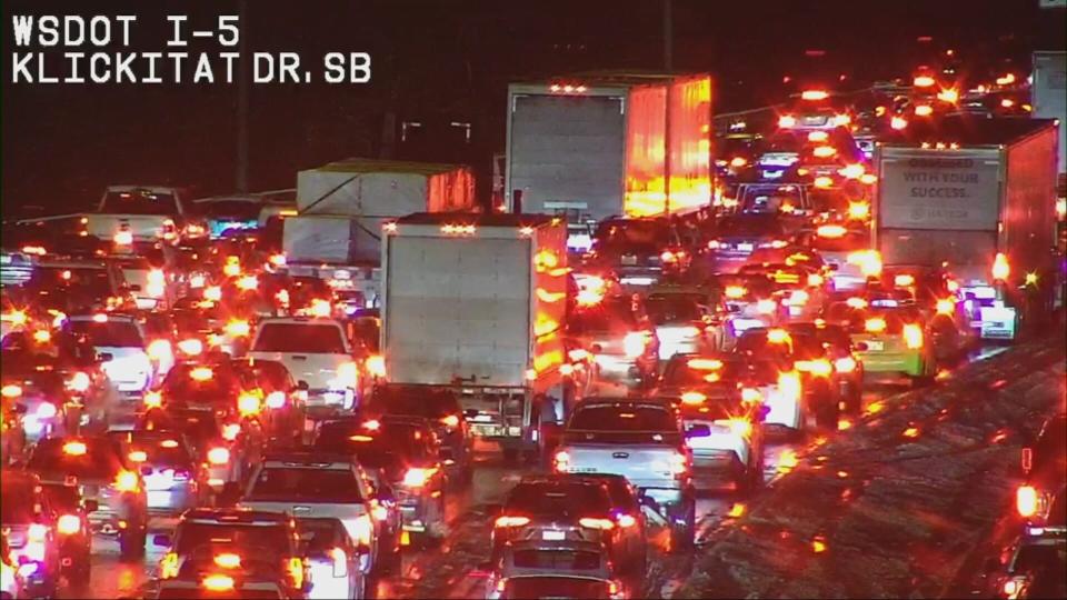
Multiple collisions have been reported throughout Puget Sound, including a state patrol car hit on southbound Interstate 5 near Southcenter Sunday evening.
At about 8:19 p.m., a Washington State Patrol car was hit near 188th, causing a large backup of vehicles.

According to sigalert.com, the backup extended from approximately Military Road to I-405.
Advertisement
Advertisement
More in U.S.
There were no serious injuries.
“If you don’t need to travel please do not. If you do, take it slow,” Trooper Rick Johnson said in a post on X.
Morgan Palmer
As pockets of snow work through Western Washington, a few of them have been vigorous enough to produce something very unusual in Western Washington: lightning, thunder, and even a waterspout while snow is going on!
KIRO 7 News Staff – 5:26 p.m.
Both directions of SR 18 are blocked over Tiger Mountain Summit for a disabled vehicle blocking all lanes.
There is no estimated time for reopening.
CLOSED: Eastbound and westbound SR 18 at Tiger Mountain summit (MP 24) is now closed due to stalled vehicles in both directions, along with heavy snow.
Please use alternate routes. There is no ETA for reopening at this time. pic.twitter.com/TMh1xgbqtD
— WSDOT Traffic (@wsdot_traffic) February 3, 2025
Collision reported on SR 8 WB at MP 15.41 near Kennedy Cr Rd SW beginning at 5:31 pm on Feb. 2, 2025 until further notice. The left lane is reported to be blocked.
— WSDOT Tacoma (@wsdot_tacoma) February 3, 2025
KIRO 7 News Staff – 3:48 p.m.
Pioneer School District near Shelton announced Sunday it will be running two hours late with no AM preschool on Monday.
Advertisement
Advertisement
Eatonville School District and Lake Quinault School District will be two hours late on Monday.
Southside School District will be 90 minutes late.
For all school closings and delays, visit our page here.
This driver tried to take the side road between MP 42 and 47 near EB 90. Maybe trying to avoid chaining up?? Either way the tow bill will not be cheap. pic.twitter.com/Awz2XlOaHw
— Trooper Rick Johnson (@wspd2pio) February 2, 2025
Advertisement
Advertisement
Morgan Palmer
Snow showers and rain/snow mix at sea level has been observed Sunday and this will continue through the remainder of the day. Most favored locations for snowfall with mainly minor accumulations are areas south of Seattle at elevations above about 300 feet, the north coast and Olympic Peninsula, and western Whatcom County.
Elsewhere, including Seattle, Tacoma, and Everett nearer sea level, the combination of slightly warmer temperatures and “snow shadowing” behind the Olympic Mountains will limit precipitation and accumulation.
Still, anywhere snow falls for an extended period of time, accumulations will result. Use caution driving the remainder of the day today and into tonight, when temperatures will fall.
Overall coverage of precipitation tapers into Sunday night and Monday morning, though there will still be some pockets of snow in the lowlands and the mountains. The best chance of snow tonight will be along the coast, south of Tacoma, and possibly western Whatcom County and along the Strait.
Advertisement
Advertisement
Even in spots that don’t have snow tonight and into Monday morning, there could be some icy patches on roads from freezing of water or snowmelt. Drivers should be especially careful early Monday on untreated, side roads and residential streets. It’s expected that main roads should remain fairly good, particularly treated roadways.
Morning lows will be in the 20s. In western Whatcom County, gusty winds out of British Columbia will force wind chills into the single digits early Monday.
While there could still be some spotty snow showers later on Monday morning, it’ll likely be dry in most areas with some breaks of sunshine. Highs will be in the 30s to near 40.
There are chances for spotty flurries or a few very light snow showers Monday night through Wednesday, though it’s expected to not be of any significance for most of the area based on present forecast data. The mountains could pick up some light accumulations. We’ll be watching the week’s forecast details closely as they evolve, as any additional moisture sent our way could increase snow chances some. But for now, it’s looking mainly dry though the week with just some flurries at times through Wednesday.
Advertisement
Advertisement
There could be another chance of snow or rain/snow mix by next weekend, though details are murky.
KIRO 7 News Staff – 1:39pm
Eastbound I-90, west of Snoqualmie Pass, has reopened to traffic.
KIRO 7 News Staff – 12:52pm
Eastbound Interstate 90 at milepost 47 is now closed, west of Snoqualmie Pass summit, due to a crash. At this time, there is no estimated time of reopening.
We have EB I-90 at MP 47 closed, west of the Snoqualmie Pass summit due to blocking collisions. No ETA to reopen. Plan for added travel time.
— Snoqualmie Pass (@SnoqualmiePass) February 2, 2025
According to FlightAware, SEA is #1 on the Misery Map, accounting for 54 flight delays and four cancellations.
Approximately 6,892 customers are without power throughout Western Washington, including 5,914 in Clallam County and 936 for Puget Sound Energy.
Morgan Palmer
We continue to see snow showers (pockets of snow, sometimes mixed with rain) continue to move onshore from the Pacific, and through this Sunday that will continue. Temperatures nearer sea level in most of our cities will be in the upper 30s to around 40 today, so just like Saturday, most lowland accumulations won’t last very long.
Advertisement
Advertisement
However, it doesn’t take long for a bit of slush and snow to accumulate on roads and sidewalks, so be very careful if out and about today.
The most favored areas for any accumulation that could cause travel issues will be in foothill locations, Whatcom County, Snohomish and Skagit Counties, along the Strait and the coast (mainly away from the beaches), and any spots above 300 feet in elevation. A Winter Weather Advisory is in effect for most of these areas.
In addition, there is the chance for an isolated lightning strike and hail shower Sunday, though this chance is pretty isolated. This could cause brief travel difficulty where ice pellets showers occur.
In the mountains, snow showers will continue through the day with more accumulations at times!
Advertisement
Advertisement
Through early Sunday evening, we’ll have some melting where wet snow falls in the lowlands and also some moisture from rain. But then temperatures fall. We will have some icy patches by Monday morning as temperatures drop a bit below freezing, so drivers beware. We’ll also have a better chance for any lowland snow to actually stick around for a while, creating minor accumulations.
I anticipate there’s a good chance of some school delays and possibly closures Monday, though that will be far more the exception than the rule. We will have you covered on the morning commute and school delays on KIRO 7 News in the Morning Monday from 4:30 a.m.
For Monday, the most likely areas to have impact from snow and icy roads will again be in the previously-mentioned areas of the foothills of the Cascades, Eastside communities (especially above a few hundred feet elevation), parts of the North Sound (especially from South Everett east through Lake Stevens and south to Snohomish and Mill Creek), Western Whatcom County and the San Juans and western Skagit County and the coast and Strait.
It continues to be important to note that while most of the area will not have significant snowy or icy travel through this period, most locations will have precipitation of some sort — be it rain, a rain/snow mix, or lightly-or-non accumulating snow. Be careful out driving because even if temperatures are above freezing, heavier precipitation that includes wet snow could cause slippery and slushy travel.
Through Monday afternoon, a very slow drying trend is noted but the precipitation type on Monday is more likely to be all snow. However, further accumulations after Monday morning should be mainly light and isolated. Highs will only be in the 30s. A few flurries are likely Tuesday with lows in the 20s and highs in the 30s.
While we maintain a mainly dry forecast, the remainder of the week beyond next Tuesday, there could be further chances for light snow we will evaluate as new data come in. This forecast for later next week is very uncertain.
It is likely to be quite cold from Tuesday through Friday with morning lows in the teens to mid-20s and highs in the low-to-mid 30s. This cold will be dangerous for the unhoused.
Also, be thinking and acting now about how you will keep your exposed exterior faucets and pipes protected, and make sure pets and animals have a warm place to be. Also, make sure (if able) to check on neighbors who might have trouble with heat.
EMEA Tribune is not involved in this news article, it is taken from our partners and or from the News Agencies. Copyright and Credit go to the News Agencies, email news@emeatribune.com Follow our WhatsApp verified Channel


