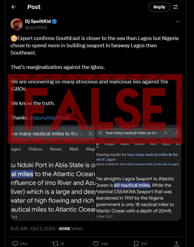
In 2020, the leadership of Nigeria’s southeastern Abia state approved the construction of a port, which has yet to break ground. Social media users have argued that Nigeria’s ports in Lagos should have originally been built in the southeastern region because it is allegedly closer to the Atlantic Ocean than their current location. However, this is false: the Lagos ports are nearer the Atlantic than the one slated to be built in the southeastern Obeaku community. Disinformation linked to these structures is part of a wider debate about the perceived marginalisation of people living in the region.
“Expert confirms SouthEast is closer to the sea than Lagos but Nigeria chose to spend more in building seaport in faraway Lagos than Southeast. That’s marginalization against the Igbos (sic),” read an X post shared more than 1,000 times since it was published on October 3, 2024.
Screenshot of false post taken on October 9, 2024
Igbo is a tribe mainly based in southeastern Nigeria (archived here), where a secessionist movement known as the Indigenous People of Biafra (IPOB) has been pushing for regional independence over claims of marginalisation and resource control.
Disinformation linked to the ports is part of a wider debate centred on the issue of restructuring, which refers to the redistribution of power between the federal and state governments. The topic has long been a point of contention in Nigeria.
Advertisement
Advertisement
The post includes two images of what appear to be screenshots of an internet search on the distance between seaports in Nigeria and the Atlantic Ocean.
The first screenshot claims the distance between the slated Obeaku Ndoki Port in Abia state and the Atlantic Ocean is 46 kilometres (25 nautical miles).
The second alleges the distance between an “almighty” seaport in Lagos and the Atlantic Ocean is 111 kilometres (60 nautical miles). It also suggested that a “potential” Oseakwa seaport would be 33 kilometres (18 nautical miles) from the Atlantic Ocean. Cultural stakeholders and lawmakers from the southeastern region argue that the creation of a port in Oseakwa would boost the region’s economy (archived here).
The claim was shared by other X accounts and on Facebook in October 2024.
Advertisement
Advertisement
Research showed it already circulated more than a year ago when it spread across social media, including here, here and here. Paschal Agbodike, a federal MP from Anambra state, also made the assertion during a legislative hearing in 2023 (archived here).
AI repeats claim
When we ran the query through Gemini AI – Google’s generative artificial intelligence tool that uses large language models to answer questions – it also claimed that ports in Nigeria’s southeast, such as the slated Obeaku Ndoki port, would be closer to the Atlantic Ocean than the ports in Lagos.
Screenshot of false prompt response from Gemini AI, taken on October 21, 2024
Perplexity.ai came up with the same result.
Screenshot of the claim repeated on Perplexity.ai taken on October 21, 2024
However, AFP Fact Check found that these statements were false.
Nigeria’s maritime hub
Nigeria borders the Gulf of Guinea – the northeasternmost part of the Atlantic Ocean – with an 853 km-long coastline (archived here).
Advertisement
Advertisement
More in World
States in Nigeria’s south and southwest are situated along the boundary of the Atlantic Ocean. These include Lagos, Ogun, Ondo, Delta, Bayelsa, Akwa Ibom, Cross River and Rivers (archived here).
Lagos, Nigeria’s maritime hub, has three seaports: Lekki, Apapa and Tincan Island.
Lekki is the newest in the state, having opened for operations in 2023.
Apapa was established in 1913, making it Nigeria’s oldest port, while Tincan Island Port was launched in 1977. Both are situated in Apapa and jointly handled 85 percent of Nigeria’s total imports in the fourth quarter of 2023 (archived here).
The distance from the Apapa Port to the Atlantic Ocean is 7.68 km (4.15 nautical miles).
Screenshot from Google Earth showing the distance from Apapa Port to the Atlantic Ocean
Tincan Island is located 11.67 km (6.3 nautical miles) from the Atlantic Ocean.
Screenshot from Google Earth showing the distance from Tincan Island Port to the Atlantic Ocean
The newly constructed Lekki Deep Sea Port is the one closest to the Atlantic Ocean in Lagos, with a distance of 3.42 km (1.85 nautical miles).
Screenshot from Google Earth showing the distance from Lekki Port to the Atlantic Ocean
Geographically incorrect
Using the measurement tool on Google Earth, AFP Fact Check found that the distance between the proposed location of the Obeaku Ndoki Port and the Atlantic Ocean is 51.53km (27.82 nautical miles) – far more than the distance between the Lagos ports and the ocean.
Advertisement
Advertisement
The distance was measured along the length of the river from the confluence of the Obeaku Ndoki River and the Azumini River to the Atlantic Ocean.
This confluence is the proposed location of the port approved for construction in 2020 (archived here).
Screenshot of Google Earth showing the distance between Obeaku Ndoki River and the Atlantic Ocean
Experts confirmed that the claims were false.
“People argue that southeastern Nigeria is not landlocked because rivers flow into one another and ultimately empties into the Atlantic Ocean,” said Kenneth Nnadi, a maritime management technology professor at the Federal University of Technology, Owerri in southeastern Nigeria.
“However, it is geographically incorrect to say the proposed ports in southeast Nigeria are closer to the Atlantic Ocean than those in Lagos. Lagos state directly borders the Atlantic,” he told AFP Fact Check.
Advertisement
Advertisement
According to reports, the suggested Oseakwa seaport would be along the Oseakwa River, in Ihiala local government area of Anambra state.
Nnadi said colonial powers once used the river to transport items for export.
AFP Fact Check compared satellite imagery from Google Earth to videos showing the location of the suggested Oseakwa seaport.
A bridge can be seen in the background of a video showing the suggested spot. An abandoned building with a brown roof can be seen at the 4’42” mark.
Screenshot showing the bridge over Oseakwa River (left), the abandoned building by Oseakwa riverbank (middle) and satellite imagery showing the bridge circled in red and the building circled in green (right)
The distance from the bridge over the Oseakwa River to the Atlantic Ocean measured 287.53km (155.26 nautical miles). The river is linked to the Atlantic Ocean using connecting water bodies in three states: Imo, Bayelsa and Rivers.
Advertisement
Advertisement
Again, this is far more than the distance between Lagos’ ports and the ocean.
Screenshot showing the distance between the proposed Oseakwa seaport and the Atlantic Ocean
Political priorities
Nnadi said the decision to establish more ports across the country is entirely up to the government.
“Ports are capital-intensive projects that require funding either from the government or private investors. With private investments, the government must approve the project. Therefore, the decision to develop ports is dependent on the political priorities of the government,” he noted
A case can be made to establish new ports in southeastern Nigeria due to the large scale of economic activities in cities like Onitsha and Aba, Nnadi added.
Advertisement
Advertisement
This, he said, would also ease the congestion at the Lagos ports and reduce the cost of transporting imported items for businesses.
AI misinformation
Enock Nyariki, the communication manager at the International Fact-Checking Network (IFCN), said that despite recent advancements, AI tools still generate false information for users.
“Even with the rapid pace of advancement in the past 24 months, all large language models still generate false information. It’s unlikely that these models will completely stop hallucinating,” Nyariki told AFP Fact Check.
“AI companies can help reduce misinformation harms by supporting media literacy campaigns and partnering with nonpartisan fact-checkers who are combating falsehoods on the frontlines.”
EMEA Tribune is not involved in this news article, it is taken from our partners and or from the News Agencies. Copyright and Credit go to the News Agencies, email news@emeatribune.com Follow our WhatsApp verified Channel


