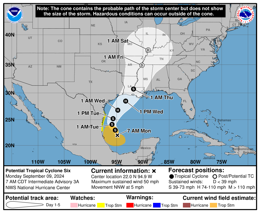
Potential Tropical Cyclone Six is expected to become Tropical Storm Francine Monday and Hurricane Francine Wednesday before making landfall in Louisiana, according to the National Hurricane Center.
The storm is currently in the Gulf of Mexico about 305 miles south-southeast of the mouth of the Rio Grande and 545 miles south of Cameron, Louisiana as of the 8 a.m. EDT advisory.
➤ In a hurry? Here’s the tropics situation in less than a minute.
➤ Weather alerts via text: Sign up to get updates about current storms and weather events by location
Sustained winds are already above the tropical storm threshold of 39 mph — the lastest measurement was 50 mph — but the disturbance is not yet organized enough to get a name. Once that happens, Tropical Storm Francine will become the sixth named storm of the 2024 Atlantic hurricane season.
Where is Potential Tropical Cyclone Six?

Interactive map: Excessive rainfall forecast
Spaghetti models: Latest models on where Potential Tropical Cyclone 6 could make landfall
Special note about spaghetti models: Spaghetti model illustrations include an array of forecast tools and models, and not all are created equal. The Hurricane Center uses only the top four or five highest performing models to help make its forecasts.
Atlantic tropics storm tracker
Weather alerts issued for Florida
What’s next?
We will continue to update our tropical weather coverage as conditions change. Download your local site’s app to ensure you’re always connected to the news. And look for our special subscription offers here.
This article originally appeared on The Daytona Beach News-Journal: Tropical storm spaghetti models: Tracker, Florida impact
EMEA Tribune is not involved in this news article, it is taken from our partners and or from the News Agencies. Copyright and Credit go to the News Agencies, email news@emeatribune.com Follow our WhatsApp verified Channel


