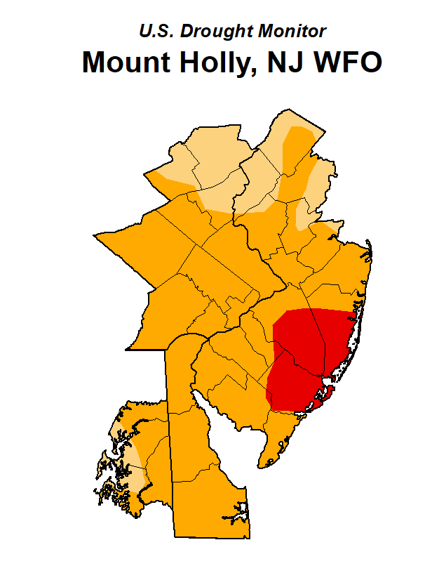
If the extreme drought at the Jersey Shore doesn’t concern you, consider this: October was the driest month in New Jersey in the past 130 years – the driest out of the last 1,558 months.
This dry spell has been so dry that it has landed on State Climatologist Dave Robinson’s list of top ten most notable weather events during his 33-year career, joining Superstorm Sandy, Hurricane Ida and the Blizzard of 1996.
The extreme drought conditions have cut right across the Pinelands, encompassing parts of Atlantic, Burlington, Ocean counties and a tiny portion of Cumberland County, according to the U.S. Drought Monitor.
Monmouth and the northern part of Ocean County is in a severe drought, officials said.
Everywhere else in New Jersey is experiencing moderate (D1) to severe drought (D2).
More: New Jersey implements Stage 3 fire safety restrictions statewide
The last time New Jersey reached the extreme drought level (D3) was in the fall of 2002, Robinson said. It actually saw exceptional drought level (D4) once since drought monitor records started to be collected in 2000, for one week in 2002.
Robinson and other experts will be weighing in next week on whether the state needs to move from a drought watch to a drought warning – a separate indicator from that used by the U.S. Drought Monitor. The next step for New Jersey would be a drought emergency, but rains expected in the coming week may diminish those prospects.

The last drought emergency was in 2002.
“We’re a long way away from consumer restrictions to water,” Robinson said. And based on the weather patterns of the last 20 years, “the rain has a way of coming in hard before droughts last very long.”
That’s all being fueled by climage change he said: intense droughts of short duration followed by heavy rains and sometimes flooding.
“Short term variability has been the key,” he said. “Some would say we were overdue. Climatologists don’t like that word. But I think the pattern we’ve seen in the last two decades is associated with our warming climate, and that prolonged droughts of a year or longer are becoming less common.”
The average rainfall for the state in October was .02 inches. The average for October over the last 30 years is 4.19 inches of rain, Robinson said.
“September really got the ball rolling,” he said. “You look at pairings of months going back to 1895, there hasn’t been anything close, in terms of dryness to the September, October of 2024.”
As of Friday:
Trenton has gone 41 days without measurable rain. The prior record was 36, in the fall of 1924.
Atlantic City Municipal Airport in Pomona has gone 37 days without. The previous record was 34 days in 1995.
Newark has gone 40 days as of Friday without measurable rainfall. The record was 26 days in spring of 1949.
The cause of all this dry weather is a “strong ridge of high pressure” over the state that has remained in place for six weeks, Robinson said. Those pressure systems cut both ways.
“It creates its own dry weather, but it also fends off wet weather,” by standing in the way of storms, he said.
New Jersey is expected to see three-quarters to an inch and a half of rain in the next seven days, he said.
How much a dent that makes in the drought remains to be seen, but it may help.
“You can’t get drier than completely dry,” Robinson said.
Ken Serrano covers crime, breaking news and investigations. Reach him at 732-643-4029 or at kserrano@gannettnj.com.
This article originally appeared on Asbury Park Press: Extreme drought at Jersey Shore could soon be cooled by rain: officlal
EMEA Tribune is not involved in this news article, it is taken from our partners and or from the News Agencies. Copyright and Credit go to the News Agencies, email news@emeatribune.com Follow our WhatsApp verified Channel


