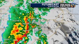
The Carolinas are in for a busy next 24 hours, with heavy rainfall and storms expected to move in on Sunday.
This system is causing a major weather outbreak across Louisiana, as well as the southeast.
It is expected to lift north overnight into Tennessee. It will reach the Carolinas on Sunday morning.
Here is the latest outlook from the Storm Prediction Center for our Sunday. The main threats are going to be damaging wind gusts and heavy rain. However, a brief weak tornado cannot be ruled out. Be sure to download the WSOC Weather App to stay prepared. pic.twitter.com/L48gtbgRhA
— Joe Puma (@JoePumaWSOC9) December 28, 2024
Expected Timeline:
-
8 a.m.: A line of storms is expected to bring heavy rain to the mountains and foothills.
-
11 a.m.: Those storms are expected to move towards the metro around.
-
3 p.m.: The storms are expected to move out of our area.
Some high-resolution models have shown solid bowing segments, which could bring damaging winds and a brief spin-up tornado threat.
Advertisement
Advertisement
The Storm Prediction Center has the entire viewing area until a level 2 out of 5 slight risk.
However, there is a 5% tornado area around Charlotte and Rock Hill.
With all this being said, the conditions have to come together perfectly for the event to occur in the morning.
There are still some questions as to how warm we will be able to get, but it is better to be prepared for the possibility of hazardous weather than to be caught off guard.
>> Channel 9′s Weather 24/7 stream has the latest local weather all day, every day. Watch wherever you stream — on our website, or through your mobile app or smart TV.
WEATHER RESOURCES:
FOLLOW OUR TEAM ON TWITTER:
EMEA Tribune is not involved in this news article, it is taken from our partners and or from the News Agencies. Copyright and Credit go to the News Agencies, email news@emeatribune.com Follow our WhatsApp verified Channel


