

Tropical storm Debby is still on track to produce “catastrophic” flooding across southeast Georgia and eastern South Carolina leading up to Friday.
This update comes from the National Hurricane Center’s (NHC) 5:00a.m. Tuesday, Aug. 6 forecast discussion regarding Debby.
Heavy rainfall will likely impact northern North Carolina, portions of Mid-Atlantic States, and southern New England through Sunday morning.
Hazardous storm surge and tropical storm conditions will also spread north along the southeast U.S. coast from northeastern Florida to North Carolina moving into the middle of the week.
Parts of Florida where Debby passed through remain in dangerous conditions including downed power lines and flooded areas.
Here’s what to know about this morning’s brief on Debby.
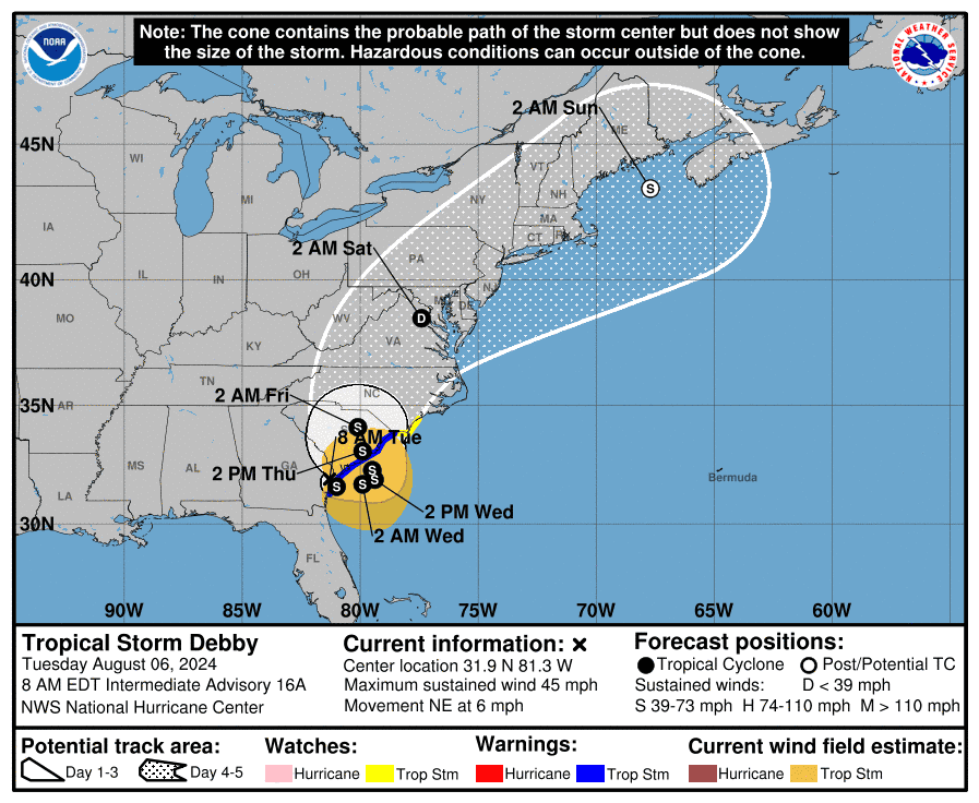
Where is Debby now? Where is it headed next?
As of 8 a.m., Aug. 6, Debby’s center was located inland over southeastern Georgia, moving toward the northeast near 6 mph, per the NHC’s public advisory. Through Thursday night, the storm will move slowly toward the east and north. Later today, the center will move offshore Georgia’s coast, drifting offshore through early Thursday. It will then move inland over S.C. on Thursday.
How much rain will Debby bring?
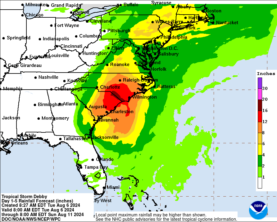
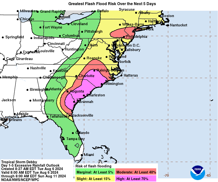
Debby is expected to produce potentially historic rainfall totals of 10 to 20 inches, with maximum amounts of 25 inches, bringing areas of catastrophic flooding across portions of the eastern half of South Carolina, and southeast North Carolina through Friday, according to the National Hurricane Center.
From northern North Carolina through portions of the Mid-Atlantic States, 4 to 8 inches of rainfall, with local amounts to 12 inches, are expected through Sunday morning. This rainfall will likely result in areas of considerable flash and urban flooding, with river flooding possible.
An additional scattered 1 to 2 inches of rainfall, with maximum amounts of 4 inches is possible across western portion of the Central Florida Peninsula and southeast Georgia today which may aggravate any ongoing flooding conditions across that vicinity.
What to know about Debby’s wind gusts
Debby currently has maximum sustained winds near 45 mph with higher wind gusts. The storm’s winds are forecast to strengthen as it moves offshore on Wednesday and Thursday. To the east of the center, tropical storm winds will extend outward up to 205 miles. Recently, sustained winds of 39 mph and a gust up to 48 mph were reported at Winyah Bay Light near Georgetown, S.C.
What advisories are currently in effect?
The National Hurricane Center announced the following weather advisories as of 8 a.m., Aug. 6:
∎ Storm Surge Warning: Altamaha Sound, Georgia to South Santee River, S.C.
∎ Storm Surge Watch: North of South Santee River, S.C. to Cape Fear, North Carolina
∎ Tropical Storm Warning: Altamaha Sound, Georgia to Little River Inlet, S.C.
∎ Tropical Storm Watch: North of Little River Inlet, S.C. to Surf City, North Carolina
Tropical storm winds across Georgia, SC, NC
Throughout the morning, tropical storm conditions are expected over areas of Georgia’s tropical storm warning area. The conditions will continue along the S.C. coast within the tropical storm warning area through Thursday night. The tropical storm warning area in North Carolina may experience the same conditions Wednesday night.
Storm surge update
Normally dry areas near the coast may be flooded by rising waters moving inland from the shoreline due to storm surge and tide. From Altamaha Sound, Georgia to Cape Fear, North Carolina, water could reach heights between 2-4 feet above ground. This may happen if the peak surge occurs during high tide.
Will Debby affect Greenville?
According to Doug Outlaw with the NWS at GSP, Greenville County is not expected to experience severe impact from the tropical storm.
“Currently, our radar is raining from Greenwood all the way to the coast and Lancaster all the way through the coast. There’s little bits of sprinkles of light rain over southern Greenville County, and kind of drifting in from northeast and the Gaffney area. But we’re not really expecting a lot of influence from Debby until Thursday, and the rainfall that’s currently ongoing is going to pretty much stay in place until Thursday because Debby is pretty much stationary,” he said.
As Debby moves into Florence, S.C., Greenville is forecast to receive rainfall amounts up to 1.35 inches, which is comparable to Charlotte’s 4 inches. Rain will rapidly increase east from Charlotte, leaving Greenville in what Outlaw calls, “pretty good shape.”
“We’re not expecting any flooding from the Greenville area,” Outlaw said. “As far as wind, we’ll get a northeast breeze from the north on Thursday and Thursday night, Thursday afternoon, with wind from 15 to 20 miles per hour with gusts around 30 miles per hour.”
On Saturday, Debby will move farther up into North Carolina and northeast away from Greenville, bringing rain in the area to an end.
Charleston County rainfall totals through Monday night
These are unofficial rainfall totals from Tropical Storm Debby through Monday night, as reported by National Weather Service volunteers.
∎ Charleston: sites ranging from 2.01 inches to 4.21 inches.
∎ Ravenel: 4.19 inches.
∎ Kiawah Island: 4.18 inches.
∎ Ace Basin: 4.16 inches.
∎ Mount Pleasant: 1.94 inches to 3.39 inches.
∎ Maryville: 3.17 inches.
∎ Seabrook Island: 2.38 to 2.87.
∎ Dewees Island: 2.28 inches.
∎ Sullivan’s Island: 1.83 inches.
∎ Wambaw: 1.44 inches.
∎ Snowden: 1.32 inches.
Nina Tran covers trending topics for The Greenville News. Reach her via email at ntran@gannett.com.
This article originally appeared on Greenville News: Tropical Storm Debby: Major flooding on South Carolina coast likely
EMEA Tribune is not involved in this news article, it is taken from our partners and or from the News Agencies. Copyright and Credit go to the News Agencies, email news@emeatribune.com Follow our WhatsApp verified Channel


