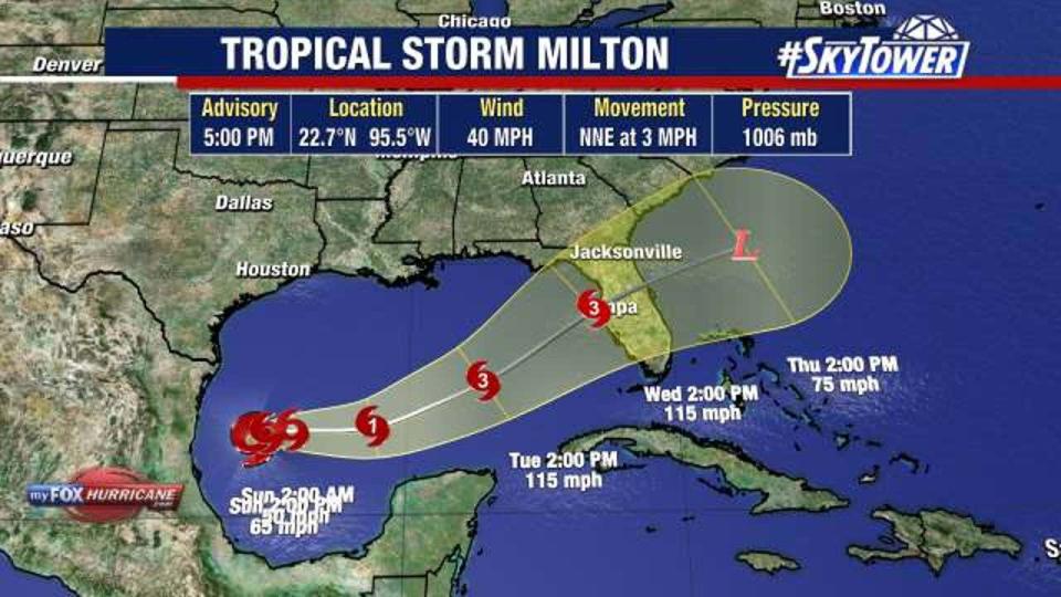
TAMPA, Fla. – Tropical Storm Milton formed in the southwestern Gulf of Mexico on Saturday morning, according to the National Hurricane Center.
This system has gained quite a bit of organization just over the last 24 hours, according to FOX 13 News Meteorologist Valerie Mills. The NHC says hurricane and storm surge watches will likely be required for portions of Florida on Sunday.
“So at this point we’re watching the west coast of Florida. We had some initial runs that were really favoring areas south of Tampa Bay, right around the southwest coast,” shared Mills.

The storm is forecast to strengthen and bring the risk of life-threatening impacts to portions of the west coast of Florida next week, according to the NHC.
There is a spread in models from Florida’s Big Bend to south of the state, but most consensus tracks the storm towards Tampa Bay.
READ: Bay Area doctor impacted by Hurricane Helene uses social media to help others with flooded homes
Hurricane Hunters are set to start flying into Tropical Storm Milton so we will learn more and likely see adjustments to the general track/strength of this storm.

Rounds of heavy rain will start for Florida on Sunday as the storm approaches from the west. Wednesday looks like the timeframe where landfall would occur, before the storm crosses the state and emerges into the Atlantic.

The exact track will determine storm surge impacts, strongest winds, and where heaviest rainfall will occur. Mills says heavy rain will be on the way for the state, with several inches of rainfall mainly Monday – Wednesday.
Models have been wavering between the strength so it’s too soon to say exactly what kind of winds the storm will bring. Some models have it becoming as strong as a Category 2 hurricane.
South of the center is where the worst of the storm surge will occur, but the heaviest rains will likely occur north of the storm’s center.
The worst of the weather will be on Wednesday and the storm is expected to be done in the Tampa Bay Area by Wednesday night.
There’s also a tropical wave off the coast of Africa that only has a low chance for development over the next week or so. Hurricane Kirk and Hurricane Leslie are both not going to impact land as they curve off to the north and further off to the north and east in the next couple of days.
STAY CONNECTED WITH FOX 13 TAMPA:
EMEA Tribune is not involved in this news article, it is taken from our partners and or from the News Agencies. Copyright and Credit go to the News Agencies, email news@emeatribune.com Follow our WhatsApp verified Channel


