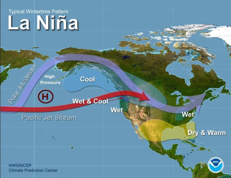
La Niña has flirted and retreated, teased and taunted, hemmed and hawed, but scientists still believe the global climate pattern will emerge in the waning weeks of 2024 bringing a warmer and drier winter to South Florida.
A seasonal forecast released by the National Weather Service and South Florida Water Management District on Nov. 18, said there is a 57% chance La Niña will develop and persist through March 2025.
Traditionally, La Niña means extended dry periods for South Florida during the darkest days of the year, a higher threat of drought and wildfires, and temperatures that are 1 to 3 degrees above normal. Rainfall is typically 10% to 30% below normal during La Niña winters.
Advertisement
Advertisement
“Forecast models are all pointing to warmer than normal temperatures extending to April,” said Robert Molleda, the meteorologist in charge at the Miami office of the NWS. “Each of the previous eight La Niña winters have led to moderate to severe drought by spring over at least parts of South Florida.”
But this La Niña has been hinting at a debut since February when the Climate Prediction Center, an office of the National Oceanic and Atmospheric Administration, issued a La Niña watch. The forecast at the time gave the atmosphere-altering phenomenon a 55% chance of waking during early summer, and a 74% chance of developing through October.
It was a no-show.
“Not every event is as easy to predict,” Molleda said. “We’ve gotten used to some fairly easy and well defined events and we’ve had several of those in the last five to 10 years but many times in the past, the signals have not been as well defined.”

La Niña climate pattern typically means warmer and drier winters for South Florida.
What are El Niño and La Niña weather patterns?
The climate patterns El Niño and La Niña are part of the powerful El Niño-Southern Oscillation, or ENSO.
Advertisement
Advertisement
La Niña happens when waters in the equatorial Pacific Ocean cool, shifting when and where tropical thunderstorms form so that the wind shear in the Atlantic Ocean wanes during hurricane season allowing budding tropical cyclones more leeway to grow.
In winter, La Niña pulses storms into the Pacific Northwest on a more northerly and inland track, holding the jet stream at higher latitudes longer where it traps cold air to its north.
During El Niño, equatorial waters warm. In summer, El Niño creates wind shear that chops up Atlantic tropical cyclones. In winter, El Niño nudges the jet stream south traditionally giving Florida cooler, wetter winters.
More: Cloudy winter in South Florida ends as coolest in years with help of El Niño
Advertisement
Advertisement
More in U.S.
But there’s no guarantee either climate pattern will behave as predicted.
Water temperatures in the Pacific did cool this past summer, but not as much as scientists expected and not to the 0.9 degrees below the long term average that is needed for a La Niña event to really stir up trouble in the tropics.
That doesn’t mean it wasn’t an active hurricane season, which ends Nov. 30.
Through Nov. 19, there were 18 named storms, which is four more than during an average year. Those included 11 hurricanes and five major hurricanes. Most notably, three hurricanes — Category 1 Debby, Category 4 Helene and Category 3 Milton — made devastating landfalls on Florida’s Gulf Coast.
Advertisement
Advertisement
“At the end of the day, it didn’t matter if La Niña was here for the tropical season,” DaSilva said. “It didn’t have a significant impact.”
And it may not have a significant impact this winter either. Because La Niña has been so tardy, it won’t have much time to strengthen, said Emily Becker, associate director of the University of Miami’s Cooperative Institute for Marine and Atmospheric Studies.
Becker writes a blog for NOAA about the El Niño Southern Oscillation. She said only two La Niña events in the 75-year historical record have formed in the October to December time frame.
A weak La Niña means other weather patterns can usurp its dominance, stirring up raucous thunderstorms despite the overall lower chances for severe weather.
Advertisement
Advertisement
The most recent La Niña event featured a strong EF-2 tornado that struck Palm Beach Gardens and North Palm Beach in April 2023. That was preceded by the historic flooding in Fort Lauderdale where more than 25 inches of rain shut down the Fort Lauderdale-Hollywood International Airport and left neighborhoods underwater for days.
During the 2016-2017 La Niña, three tornadoes hit southeast Florida including one that buzzed through Palm Beach Gardens and Juno Beach with peak winds of about 90 mph.
“The only thing we can say for certain is that nature is going to keep us guessing,” Becker said in her blog about La Niña. “We’ve been saying it for months, and we are saying it again: Forecasters still think La Niña will develop and last through the winter.”
Kimberly Miller is a journalist for The Palm Beach Post, part of the USA Today Network of Florida. She covers real estate, weather, and the environment. Subscribe to The Dirt for a weekly real estate roundup. If you have news tips, please send them to kmiller@pbpost.com. Help support our local journalism, subscribe today.
This article originally appeared on Palm Beach Post: La Nina expected to emerge by end of year meaning warmer, drier winter
EMEA Tribune is not involved in this news article, it is taken from our partners and or from the News Agencies. Copyright and Credit go to the News Agencies, email news@emeatribune.com Follow our WhatsApp verified Channel


