November 30 officially brings the Atlantic hurricane season to a close. But that doesn’t mean you can’t have tropical development after that, as history has shown.
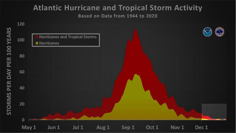
What the season means: The “official” Atlantic hurricane season was eventually defined in 1965 to be from June through November, easiest for people to remember. According to NOAA’s Hurricane Research Division, that six-month period encompasses over 97% of Atlantic Basin storm activity.

After hurricane season activity December January
December, and even later storms: As often in life, not everything fits into nice, neat buckets. There’s always outliers.
Advertisement
Advertisement
As you can see in the graph above, some activity can happen after November, as well as before June. We detailed the pre-June storms in this previous piece.
NOAA’s database documented 13 storms formed in December since 1851. The last one was an unnamed subtropical storm in early December 2013. Four of those 13 storms became hurricanes, that last of which was 1984’s Hurricane Lili, which happened just five days before Christmas.
Five other storms have developed in January. Two of those have been recently, including an unnamed subtropical storm off the U.S. East Coast in 2023 and 2016’s bizarre Hurricane Alex in the eastern Atlantic Ocean, the strongest January Atlantic hurricane on record.
As you can see in the track map below, these few December and January storms tend to remain over the open Atlantic Ocean far from land.
(Further beef up your forecast with our detailed, hour-by-hour breakdown for the next 8 days – only available on our Premium Pro experience.)

After hurricane season activity December January
But some have been impactful: Not all of these off-season weirdos have been “fish storms”, though.
Advertisement
Advertisement
The aforementioned Hurricane Alex made landfall in the Azores as a tropical storm in January 2016.
Tropical Storm Olga triggered deadly flooding in Hispaniola in December 2007.
One day after New Year’s 1955, Hurricane Alice carved through parts of the northern Leeward Islands, producing wind gusts up to 81 mph and flooding rain.
NOAA’s ongoing Atlantic Hurricane Database Re-analysis Project found the only February Atlantic Basin tropical storm on record damaged crops in South Florida on Groundhog Day, 1952.
The project also found an early March 1908 hurricane hit the Leeward Islands, damaging buildings and crops.

How can this happen: Usually there’s far too much wind shear, dry and cooler air and cooler water to allow development after hurricane season. So, we need something else to happen.
Advertisement
Advertisement
More in U.S.
“Usually, storms that form after the season do so from non-tropical sources, including upper-level lows and cold fronts,” National Hurricane Center senior hurricane specialist, Eric Blake, told weather.com in 2017.
“A common scenario is when an upper-low cuts off and sits over warmer-than-normal water for a few days beneath a blocking pattern.”
You can see that happen in the case of 2016’s Hurricane Alex in the satellite loop below.
MORE ON WEATHER.COM
– Winter Outlook Travel Tips From A Meteorologist
– What Does ‘Meteorological Winter’ Mean?
Jonathan Erdman is a senior meteorologist at weather.com and has been covering national and international weather since 1996. Extreme and bizarre weather are his favorite topics. Reach out to him on Bluesky, X (formerly Twitter) and Facebook.
EMEA Tribune is not involved in this news article, it is taken from our partners and or from the News Agencies. Copyright and Credit go to the News Agencies, email news@emeatribune.com Follow our WhatsApp verified Channel


