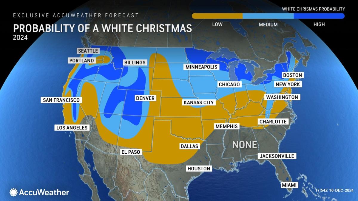
A White Christmas in upstate New York is looking more and more likely. With several inches of snow already on the ground, it isn’t a certainty, but is certainly likely, said Meteorologist Bob Hamilton of the National Weather Service in Buffalo.
A system is expected to move through western New York on Monday, bringing another 1 to 3 inches of snow to much of the state, including the Rochester region. Coupled with the seasonably cooler temperatures, which are below freezing through at least Monday, snow is expected to “stick around for Christmas Day,” he said.
Such a forecast, he said, is not a complete certainty, but roughly a 75 to 80% chance. And the highs in the coming days are cooler than normal with a predicted high Sunday in the teens and in the low to mid-30s between Monday and Thursday. Later in the week, Hamilton said, warmer highs are predicted – in the low to mid 40s. The normal high in upstate New York the week of Christmas is in the upper 30s.
Snow forecast map: See snowfall projections by day
The map below shows the probability that an area could receive more than 4 inches of snow in the U.S. See New York projections. Use the slider at the top left to toggle by day.
What is a white Christmas?
It doesn’t need to snow Dec. 25 to fit the Weather Service’s definition of a white Christmas. There just needs to be at least one inch of snow on the ground. A trace amount of snow also does not count. On average, about 38% of the Lower 48 has an inch of snow on the ground on Christmas Day, according to 21 years of data compiled by NOAA.
Advertisement
Advertisement
Since 2003, those percentages have varied widely from year to year, from only 17.6% last year to a whopping 63% of the contiguous U.S. in 2009, according to Weather.com.
Three New York cities are snow central
For big cities of at least 100,000 residents, three in Western New York take the prize for snowiest, according to National Weather Service data.
Thanks primarily to lake-effect snow, the nation’s snowiest big city is Syracuse, which gets roughly 11 feet of snow per winter season, according to the National Weather Service. It’s also one of the nation’s rainiest and cloudiest cities. Other cities in western New York, such as Rochester and Buffalo, average about 9 feet per year, again due to the lake effect.
To date this year – 20.4 inches has fallen in Buffalo and 18.4 inches has fallen in Syracuse. Rochester’s seasonal snowfall has surpassed a foot, but exact numbers were not available after Friday, forecasters said. However, Binghamton – which is about 70 miles south of Syracuse – has already tallied more than 34 inches of snow this winter, according to the Weather Service.
Advertisement
Advertisement
“Lake-effect snow generated by the Great Lakes is among the heaviest snowfall in the world,” said Weather.com meteorologist Jonathan Erdman in an online report.
One of the most noteworthy lake-effect snowfalls in New York occurred over a 10-day period between Feb. 3 and 12, 2007, when 141 inches of snow (that’s 11.75 feet) were measured in the town of Redfield, Oswego County, about 50 miles northeast of Syracuse, near Lake Ontario.
This article originally appeared on Rochester Democrat and Chronicle: White Christmas in New York? What the latest forecast says
EMEA Tribune is not involved in this news article, it is taken from our partners and or from the News Agencies. Copyright and Credit go to the News Agencies, email news@emeatribune.com Follow our WhatsApp verified Channel


