MELBOURNE, Fla. – As a disturbance off the coast of Florida continues to swirl, forecasters have issued multiple warnings that beachgoers should pay attention to.
Satellite imagery showed that shower activity associated with the area of low pressure about 175 miles north-northeast of the northern Bahamas had become slightly better organized over the past 24 hours, according to the National Hurricane Center. However, earlier data from Air Force Reserve Hurricane Hunter aircraft indicated that the system does not yet have a well-defined circulation.
Environmental conditions remain marginally conducive, at about 50%, for further development, and this system could become a tropical depression as it moves west-northwestward.
Even if this system doesn’t develop, it’s still expected to bring hazardous conditions to all of Central Florida’s beaches, according to the National Weather Service office in Melbourne. That includes bands of breezy to gusty showers, isolated storms north of Cape Canaveral, and a high risk of life-threatening rip currents with large breaking waves along the coast.
4:20PM 6/20 | We continue to monitor a disturbance in the Atlantic which will arrive early Friday. This will bring a period of showers from Orlando to Cape Canaveral northward, as surf and marine conditions remain hazardous. Chance of development still 40%. #FLwx pic.twitter.com/LQ5RejBA1e
— NWS Melbourne (@NWSMelbourne) June 20, 2024
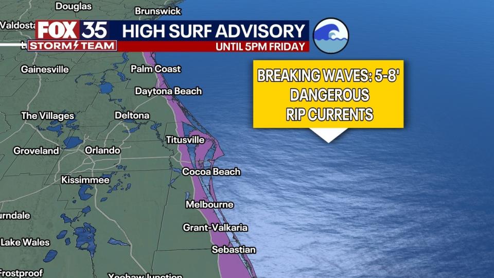
A high surf advisory is in effect until 4 a.m. Friday for the following areas in Volusia, Brevard, Indian River, St. Lucie and Martin counties:
Jun 20 | Another breezy day is forecast with wind gusts increasing between 20-25 mph. There is a high risk of life-threatening rip currents with large breaking waves at all central Florida Atlantic beaches. Beachgoers should remain out of the water! pic.twitter.com/byA10skVbz
— NWS Melbourne (@NWSMelbourne) June 20, 2024
The surf on Thursday at Volusia and Brevard county beaches is expected to reach 5 to 7 feet. On Friday, the surf height is an estimated 3 to 6 feet.
” src=”https://s.yimg.com/ny/api/res/1.2/fePLqFr2_XwntO2etl3AZg–/YXBwaWQ9aGlnaGxhbmRlcjt3PTk2MDtoPTU0MA–/https://media.zenfs.com/en/wofl_fox_local_articles_124/baadb4dba55d6fc035448647bea998bb” class=”caas-img”>