


As Invest 92L approaches the Florida-Georgia coast Friday morning, the National Hurricane Center also is tracking another system in the Gulf of Mexico.
Both tropical disturbances have the potential of developing into a tropical depression, although the window of opportunity is small for Invest 92L.
The small area of showers and thunderstorms designated as Invest 92L is expected to reach the coast by Friday night.
In the southwestern Gulf of Mexico, environmental conditions appear favorable for a tropical depression to develop over the weekend.
➤ WeatherTiger on Invest 92L: Impacts on Florida will be little different than a typical day in June
The next named storm of the 2024 Atlantic hurricane season will be Beryl.
Here’s the latest update from the NHC as of 8 a.m., June 21:
Invest 92L: Where is it and how could it impact Florida?
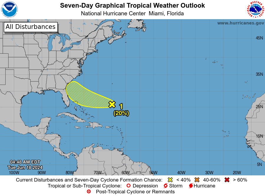
Invest 92L: A small area of showers and thunderstorms persists with a low pressure system located around 150 miles east-southeast of Jacksonville.
An Air Force Reserve aircraft is currently investigating the system to determine if the low has a well-defined surface circulation.
Environmental conditions remain marginally conducive for some additional development, and this system could become a short-lived tropical depression as the low moves west-northwest at 10 to 15 mph.
The system is expected to reach the coast of northeastern Florida or Georgia by tonight, and residents should monitor its progress.
Formation chance through 48 hours: medium, 50 percent.
Formation chance through 7 days: medium, 50 percent.
92L impact on Florida: Invest 92L approaching Florida, Georgia. Track system, see possible impacts
Spaghetti models for Invest 92L as it moves toward Florida, Georgia
Special note about spaghetti models: Illustrations include an array of forecast tools and models, and not all are created equal. The hurricane center uses only the top four or five highest performing models to help make its forecasts.
➤ Storm sequel on horizon? Alberto targets Texas, ‘featherweight’ system nears Florida
What else is out there and how likely is it to strengthen?
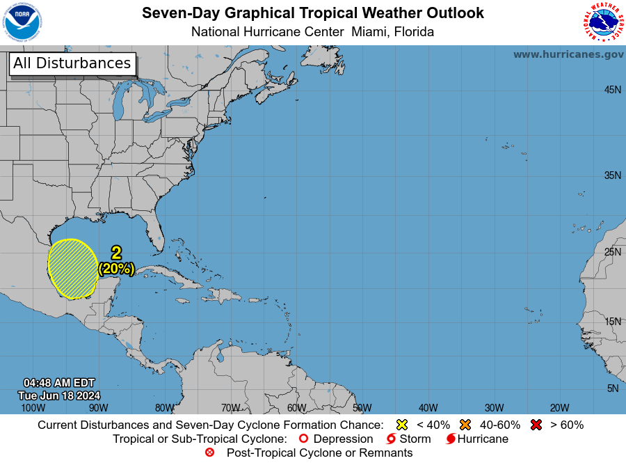
Southwestern Gulf of Mexico: A broad area of low pressure is forecast to form over southeastern Mexico later today.
Environmental conditions appear conducive for gradual development after this system moves over the Bay of Campeche tonight, and a tropical depression could form over the southwestern Gulf of Mexico this weekend while it moves slowly west-northwest or northwest.
Residents along the Gulf Coast of Mexico should monitor the progress of this system.
Formation chance through 48 hours: medium, 50 percent.
Formation chance through 7 days: medium, 60 percent.
Who is likely to be impacted?
Invest 92L: “Regardless of development, this feature can bring high seas, gusty winds and areas of heavy rain and thunderstorms to the Southeast coast,” said AccuWeather Meteorologist Andrew Kienzle.
Rip currents will increase in strength and frequency from the east-central coast of Florida to North Carolina.
“Within the heavier rain bands, localized flash flooding can occur,” AccuWeather Senior Meteorologist Alex Sosnowski said,
Wind gusts directly along the coastline could reach 25-35 mph as the invest moves northwest, AccuWeather said.
Southwestern Gulf of Mexico: This system will need to be watched for “possible impacts on the Gulf coasts of the United States and Mexico this weekend into early next week,” Kienzle said.
Depending on the intensity and track of this new disturbance, rain, wind, coastal flooding and surf will likely build along much of the Texas and northeastern Mexico coasts again, according to AccuWeather.
Forecasters urge all residents to continue monitoring the tropics and to always be prepared. That advice is particularly important for what is expected to be a very active hurricane season.
Weather watches and warnings issued in Florida
When is the Atlantic hurricane season?
The Atlantic hurricane season runs from June 1 through Nov. 30.
When is the peak of hurricane season?
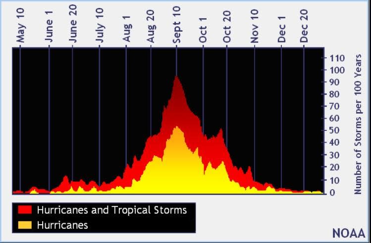
The peak of the season is Sept. 10, with the most activity happening between mid-August and mid-October, according to the Hurricane Center.
National Hurricane Center map: What are forecasters watching now?
Systems currently being monitored by the National Hurricane Center include:
Interactive map: Hurricanes, tropical storms that have passed near your city
Excessive rainfall forecast
What’s next?
We will continue to update our tropical weather coverage daily. Download your local site’s app to ensure you’re always connected to the news. And look for our special subscription offers here.
This article originally appeared on Treasure Coast Newspapers: NHC: Tropical depressions possible off Florida, Gulf of Mexico
EMEA Tribune is not involved in this news article, it is taken from our partners and or from the News Agencies. Copyright and Credit go to the News Agencies, email news@emeatribune.com Follow our WhatsApp verified Channel


