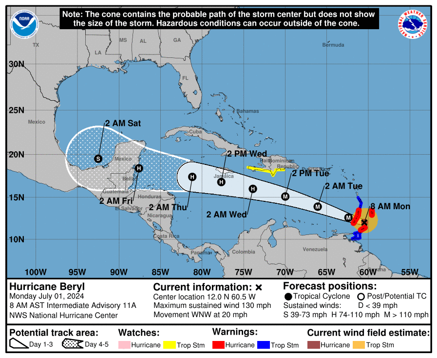
Hurricane Beryl made landfall Monday as a Category 4 storm on Grenada’s Carriacou Island, packing 150 mph wind.
Now hitting wind speeds of 165 mph, Beryl is a Category 5 storm as of Tuesday morning.
Hurricane Beryl formed Friday night, according to the National Hurricane Center, and it became a hurricane late Saturday afternoon, ramping up to a Category 4 storm Sunday.
Named storms this early in the season are rare, especially major hurricanes. AccuWeather said seven named storms have formed in the Atlantic before July 4. According to Weather Underground, there have been only four hurricanes that have reached Category 3 status (111-129 mph sustained winds) before the end of June.
Should Pensacola residents be worried? AccuWeather forecasters currently don’t expect any impact to the U.S. but if high pressure across the Southeast weakens, Beryl could impact the Gulf Coast.
Here’s what the latest spaghetti models say:
Spaghetti models for Hurricane Beryl
Special note about spaghetti models: Illustrations include an array of forecast tools and models, and not all are created equal. The hurricane center uses only the top four or five highest performing models to help make its forecasts.
Hurricane Beryl path tracker
Where is Hurricane Beryl? National Hurricane Center forecast cone

Current weather advisories across Florida
Hurricane Beryl projected wind speeds
-
12 hours: 145 mph
-
24 hours: 140 mph
-
36 hours: 125 mph
-
48 hours: 120 mph
-
60 hours: 115 mph
-
72 hours: 110 mph
-
96 hours: 100 mph
-
120 hours: 70 mph inland
This article originally appeared on Pensacola News Journal: Hurricane Beryl projected path, spaghetti models, storm track
EMEA Tribune is not involved in this news article, it is taken from our partners and or from the News Agencies. Copyright and Credit go to the News Agencies, email news@emeatribune.com Follow our WhatsApp verified Channel


